
~ Beaufort NC topo map, 1:250000 scale, 1 X 2 Degree, Historical, 1953, updated 1965
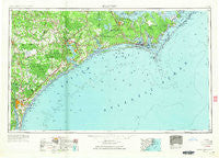
Beaufort, North Carolina, USGS topographic map dated 1953.
Includes geographic coordinates (latitude and longitude). This topographic map is suitable for hiking, camping, and exploring, or framing it as a wall map.
Printed on-demand using high resolution imagery, on heavy weight and acid free paper, or alternatively on a variety of synthetic materials.
Topos available on paper, Waterproof, Poly, or Tyvek. Usually shipping rolled, unless combined with other folded maps in one order.
- Product Number: USGS-5374998
- Free digital map download (high-resolution, GeoPDF): Beaufort, North Carolina (file size: 12 MB)
- Map Size: please refer to the dimensions of the GeoPDF map above
- Weight (paper map): ca. 55 grams
- Map Type: POD USGS Topographic Map
- Map Series: HTMC
- Map Verison: Historical
- Cell ID: 68666
- Scan ID: 163713
- Imprint Year: 1965
- Woodland Tint: Yes
- Edit Year: 1964
- Field Check Year: 1953
- Datum: Unstated
- Map Projection: Transverse Mercator
- Map published by United States Geological Survey
- Map Language: English
- Scanner Resolution: 600 dpi
- Map Cell Name: Beaufort
- Grid size: 1 X 2 Degree
- Date on map: 1953
- Map Scale: 1:250000
- Geographical region: North Carolina, United States
Neighboring Maps:
All neighboring USGS topo maps are available for sale online at a variety of scales.
Spatial coverage:
Topo map Beaufort, North Carolina, covers the geographical area associated the following places:
- Conner Village - Lyman - Tusk - Lakewood - New River - Murraysville - River Road Estate Mobile Home Park - Peletier - Ashley Place - The Palms Mobile Home Park - Myrtle Grove - Wildwood Mobile Home Park - South Oleander - Fairlawn - Houston Mobile Home Park - Princess Place - Crotan Mobile Home Park - Deppe - Masontown - Berkeley Manor Area - Brown Town - Folkstone - Rollingwoood Acres - Watsons Mobile Home Park - Acorn Forest - Hawkside - Lauradale - Hilltop Acres - Ashton - Utopia Mobile Home Park - Ramseys Mobile Home Park - Town and Country Mobile Home Park - Pine Forest Acres - Lillipad Mobile Home Park - Kirkland - Riverfront Mobile Home Park - Oceanway Mobile Home Park - Apple Mobile Home Park - Topsail - Steep Pines Fork - Janeiro - Stacy - Birchwood Park - Davis Mobile Home Park - Half Moon Heights - Sunshine Acres Mobile Home Park - Gum Branch - Shamrock Mobile Home Park - Glynnwood Mobile Home Park - Skippers Corner - Creekside Mobile Home Park - Highsmith - Atlantic - Ocean View - Manteo - The Black Cat - Plear - Himobile Mobile Home Park - Twin Oak - Sand Mobile Home Park - Langleys Mobile Home Park Number 2 - Dixon - Shell Bank - Comfort Country Homes - Aldersgate - Straits - Mill Creek - Kuhns - Sherwood Forest - Lola - Neuse Forest - Edgewood Park - Oak Grove - Oakcrest - Newport - Echo Farms - Oaksmith Acres - Watkins Village - Hanby Beach - Triple H Mobile Home Park - Oakwood - Crab Point Village - Old Grove Mobile Home Park - Sealevel - Silver Lake - Anchor View Mobile Home Estates - North Harbor - Lake and Shores Estates - Belgrade - Atlantic Mobile Home Park - Sandwinds Mobile Home Park - Ocean - Masonboro - Ervintown - Bryan Mobile Home Park - Bonham Heights - Marshallberg - Half Moon - Indian Beach - Queens Point
- Map Area ID: AREA3534-78-76
- Northwest corner Lat/Long code: USGSNW35-78
- Northeast corner Lat/Long code: USGSNE35-76
- Southwest corner Lat/Long code: USGSSW34-78
- Southeast corner Lat/Long code: USGSSE34-76
- Northern map edge Latitude: 35
- Southern map edge Latitude: 34
- Western map edge Longitude: -78
- Eastern map edge Longitude: -76


