
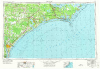
~ Beaufort NC topo map, 1:250000 scale, 1 X 2 Degree, Historical, 1953, updated 1974
Beaufort, North Carolina, USGS topographic map dated 1953.
Includes geographic coordinates (latitude and longitude). This topographic map is suitable for hiking, camping, and exploring, or framing it as a wall map.
Printed on-demand using high resolution imagery, on heavy weight and acid free paper, or alternatively on a variety of synthetic materials.
Topos available on paper, Waterproof, Poly, or Tyvek. Usually shipping rolled, unless combined with other folded maps in one order.
- Product Number: USGS-5374996
- Free digital map download (high-resolution, GeoPDF): Beaufort, North Carolina (file size: 20 MB)
- Map Size: please refer to the dimensions of the GeoPDF map above
- Weight (paper map): ca. 55 grams
- Map Type: POD USGS Topographic Map
- Map Series: HTMC
- Map Verison: Historical
- Cell ID: 68666
- Scan ID: 163712
- Imprint Year: 1974
- Woodland Tint: Yes
- Aerial Photo Year: 1970
- Edit Year: 1971
- Field Check Year: 1953
- Datum: Unstated
- Map Projection: Transverse Mercator
- Map published by United States Geological Survey
- Map Language: English
- Scanner Resolution: 600 dpi
- Map Cell Name: Beaufort
- Grid size: 1 X 2 Degree
- Date on map: 1953
- Map Scale: 1:250000
- Geographical region: North Carolina, United States
Neighboring Maps:
All neighboring USGS topo maps are available for sale online at a variety of scales.
Spatial coverage:
Topo map Beaufort, North Carolina, covers the geographical area associated the following places:
- Ocean View - Smyrna - Lake and Shores Estates - Sloop Point - Bachelor - Brynn Marr - Spooners Creek East Harbor - Willard - Huffmantown - Comfort Country Homes - Kuhns - Petersburg - Aldersgate - Bryan Mobile Home Park - Rollingwoood Acres - Cartersville - Fulcher Landing - Royal Palms Mobile Home Park - Harlowe - Georgetown - Holly Ridge - Sound of the Sea - Mandy Farms - Money Island Beach - Masonboro - Oakhurst River Estates - Ketner Heights - Long Leaf Acres - Peletier - Mill Creek - Pasley - Westridge Mobile Home Park - New River - Westwood Heights - Grants Mobile Home Park - Myrtle Grove - Point Emerald Villas - Hadley - Langleys Mobile Home Park Number 2 - Highland Pines Mobile Home Park - Montford Point - Bay Woods - Bertram Mobile Home Park - Montclair - Riverside Mobile Home Park - Country Club Hills - Bogue View Shores - Warrens Trailer Park - South Gate Mobile Home Park - Walkers - Houston Mobile Home Park - Northwoods Park - Silverdale - Shaken - Forest Hills - Beulaville - Sanderson Mobile Home Park - Powells Mobile Home Park - Twin Oaks Mobile Home Park - Camp Seagull - Riverdale - Old Grove Mobile Home Park - Holly Hills Mobile Home Estate - Spooners Creek Harbor - Chadwick - Sea Breeze - Hawkside - Hallsville - Havelock Manor - Emerald Isle - South River - Twin Cedar Mobile Home Park - Queen Creek Mobile Home Park - Hinsons Mobile Home Park - Lakewood - Bayshore - Kellum - Cherry Point (historical) - Potters Mobile Home Park - Seagate - Bonham Heights - Kathy Anns Mobile Home Park - Royal Valley Mobile Home Park - Branchwood - Gum Branch - Straits Haven - Lauradale - Sunrise Point - Springdale Acres - Tarawa Terrace II - Wetherington's Mobile Home Park - Beaufort - Twin Pines Mobile Home Park - Watha - Morton Manor - Stacy - Coastal Shores - Surf City - Pine Grove - Hillcrest Mobile Home Subdivision
- Map Area ID: AREA3534-78-76
- Northwest corner Lat/Long code: USGSNW35-78
- Northeast corner Lat/Long code: USGSNE35-76
- Southwest corner Lat/Long code: USGSSW34-78
- Southeast corner Lat/Long code: USGSSE34-76
- Northern map edge Latitude: 35
- Southern map edge Latitude: 34
- Western map edge Longitude: -78
- Eastern map edge Longitude: -76


