
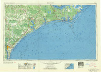
~ Beaufort NC topo map, 1:250000 scale, 1 X 2 Degree, Historical, 1954
Beaufort, North Carolina, USGS topographic map dated 1954.
Includes geographic coordinates (latitude and longitude). This topographic map is suitable for hiking, camping, and exploring, or framing it as a wall map.
Printed on-demand using high resolution imagery, on heavy weight and acid free paper, or alternatively on a variety of synthetic materials.
Topos available on paper, Waterproof, Poly, or Tyvek. Usually shipping rolled, unless combined with other folded maps in one order.
- Product Number: USGS-5374994
- Free digital map download (high-resolution, GeoPDF): Beaufort, North Carolina (file size: 28 MB)
- Map Size: please refer to the dimensions of the GeoPDF map above
- Weight (paper map): ca. 55 grams
- Map Type: POD USGS Topographic Map
- Map Series: HTMC
- Map Verison: Historical
- Cell ID: 68666
- Scan ID: 163711
- Woodland Tint: Yes
- Field Check Year: 1953
- Datum: Unstated
- Map Projection: Transverse Mercator
- Map published by United States Army Corps of Engineers
- Map published by United States Army
- Map Language: English
- Scanner Resolution: 600 dpi
- Map Cell Name: Beaufort
- Grid size: 1 X 2 Degree
- Date on map: 1954
- Map Scale: 1:250000
- Geographical region: North Carolina, United States
Neighboring Maps:
All neighboring USGS topo maps are available for sale online at a variety of scales.
Spatial coverage:
Topo map Beaufort, North Carolina, covers the geographical area associated the following places:
- Atlantic Mobile Home Park - Greenbriar - Mitchell Village - Colonial Hills - Carolina Country - Marshallberg - Falcon Point - Anchor View Mobile Home Estates - James McDowell Jr Mobile Home Park - Aragona Village - College Acres - Port-O-Pines Estates - Northwoods Park - Norris Mobile Home Village - Tarawa Terrace I - Lincoln Forest - Hubert - Broad Creek - Jerrett Estates - Pasley - Riverdale - North River Corner - Stoneybrook - Belville - Royal Valley Mobile Home Park - West Onslow Beach - Edgecombe - The Haystacks - Forest Grove - Bells Crossroads - White Oak Estates - Forest Hills - Queens Court - Neuse Forest - Myrtle Grove Junction - Lenoxville - Coastal Mobile Estates - Crab Point Village - Ramseys Mobile Home Park - Janeiro - Hampstead - Cedar Fork - Mandy Farms - Myrtle Sound - North Harlowe - Shelter Neck - Roe - Gregory Forks - Brandywine - Croatan - Sunshine Acres Mobile Home Park - Greystone Estates - Channel Acres - Montclair - Hancheys Store - Glynnwood Mobile Home Park - James Mobile Home Park - Park Place Mobile Home Park - Comfort Country Homes - Docs Mobile Home Park - Duck Creek - Hawkside - Tanglewood - Brynn Marr - Summersill Estates - Camp Don-Lee - Thornes Farm Trailer Park - Treasure Cove - Tar Landing - Southridge Mobile Home Park - Cherry Point Landing (historical) - Hadley - Houston Heights - The Pines Mobile Home Park - Exeter (historical) - Little Kelly - Creekside Mobile Home Park - Atlantic - Delgado - Bucks Corner - Blades - Montford Point - Woodside - Greenfields Heights - Westwood Heights - Warrens Trailer Park - Holly Ridge - Castle Hayne - Wrightsboro Acres - Dixon - Carolina City - Sound of the Sea - Van Eden - Ocean View - Greenevers - Timberland Village Mobile Home Park - Foxhorn Village - Ashton - Ervintown - Gum Branch
- Map Area ID: AREA3534-78-76
- Northwest corner Lat/Long code: USGSNW35-78
- Northeast corner Lat/Long code: USGSNE35-76
- Southwest corner Lat/Long code: USGSSW34-78
- Southeast corner Lat/Long code: USGSSE34-76
- Northern map edge Latitude: 35
- Southern map edge Latitude: 34
- Western map edge Longitude: -78
- Eastern map edge Longitude: -76


