
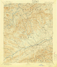
~ Wilkesboro NC topo map, 1:125000 scale, 30 X 30 Minute, Historical, 1891, updated 1940
Wilkesboro, North Carolina, USGS topographic map dated 1891.
Includes geographic coordinates (latitude and longitude). This topographic map is suitable for hiking, camping, and exploring, or framing it as a wall map.
Printed on-demand using high resolution imagery, on heavy weight and acid free paper, or alternatively on a variety of synthetic materials.
Topos available on paper, Waterproof, Poly, or Tyvek. Usually shipping rolled, unless combined with other folded maps in one order.
- Product Number: USGS-5374988
- Free digital map download (high-resolution, GeoPDF): Wilkesboro, North Carolina (file size: 9 MB)
- Map Size: please refer to the dimensions of the GeoPDF map above
- Weight (paper map): ca. 55 grams
- Map Type: POD USGS Topographic Map
- Map Series: HTMC
- Map Verison: Historical
- Cell ID: 66948
- Scan ID: 164018
- Imprint Year: 1940
- Survey Year: 1889
- Datum: Unstated
- Map Projection: Polyconic
- Map published by United States Geological Survey
- Map Language: English
- Scanner Resolution: 600 dpi
- Map Cell Name: Wilkesboro
- Grid size: 30 X 30 Minute
- Date on map: 1891
- Map Scale: 1:125000
- Geographical region: North Carolina, United States
Neighboring Maps:
All neighboring USGS topo maps are available for sale online at a variety of scales.
Spatial coverage:
Topo map Wilkesboro, North Carolina, covers the geographical area associated the following places:
- Peden - Forest Hills - Pine Swamp - Sherwood Forest - Roaring River - Antioch - Wilbar - Glendale Springs - Lenoir (historical) - Hunting Creek (historical) - Edgewood - Obids - Hilltop Acres - Newlife (historical) - Mount Pleasant - Yates - Oakdale - Finley Park - Buck - Moxley - East Fruitland (historical) - Country Club Hills - Dellaplane - Robinet (historical) - Henderson (historical) - Pattons Ridge - Cherry Lane - Sunset Falls - Wilkesboro - Call - Rolling Pine Acres - Scottville - Oakwoods - Jefferson - Springfield (historical) - Idlewild - Denny (historical) - Westwood Hills - Vannoy - Maple Springs - Hendrix (historical) - Chuckle (historical) - Offer (historical) - Walsh (historical) - Millers Creek - Traphill - Zebra (historical) - Transou - Lester (historical) - Fishing Creek - Fletcher (historical) - Halls Mills - Ready Branch - West Jefferson - Parsonville - Mertie (historical) - Fort Defiance - Nathans Creek - Spurgeon (historical) - Ferguson - Wagoner - Knottville - Dockery - Glade Valley - Knollwood - Abshers - Thankful - Mount Zion - Darby - Shatley Springs - Stony Fork - Wildwood Park - Boomer - Fox Run - Yadkin Valley - Hays - Grandin - Brown (historical) - Purlear - Cricket Park - Staunton - Wallace Acres - Harley - Whitehead - Pleasant Grove - Elkville - Ore Knob - Bryan (historical) - Mayview Acres - Quail Hollow Estates - Laurel Springs - Othello - Russaw (historical) - Hays Arbor - Orion - New Hope - Cricket - Hilorn (historical) - Mulberry - Old Gilreath
- Map Area ID: AREA36.536-81.5-81
- Northwest corner Lat/Long code: USGSNW36.5-81.5
- Northeast corner Lat/Long code: USGSNE36.5-81
- Southwest corner Lat/Long code: USGSSW36-81.5
- Southeast corner Lat/Long code: USGSSE36-81
- Northern map edge Latitude: 36.5
- Southern map edge Latitude: 36
- Western map edge Longitude: -81.5
- Eastern map edge Longitude: -81


