
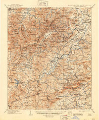
~ Pisgah NC topo map, 1:125000 scale, 30 X 30 Minute, Historical, 1906, updated 1946
Pisgah, North Carolina, USGS topographic map dated 1906.
Includes geographic coordinates (latitude and longitude). This topographic map is suitable for hiking, camping, and exploring, or framing it as a wall map.
Printed on-demand using high resolution imagery, on heavy weight and acid free paper, or alternatively on a variety of synthetic materials.
Topos available on paper, Waterproof, Poly, or Tyvek. Usually shipping rolled, unless combined with other folded maps in one order.
- Product Number: USGS-5374970
- Free digital map download (high-resolution, GeoPDF): Pisgah, North Carolina (file size: 12 MB)
- Map Size: please refer to the dimensions of the GeoPDF map above
- Weight (paper map): ca. 55 grams
- Map Type: POD USGS Topographic Map
- Map Series: HTMC
- Map Verison: Historical
- Cell ID: 66346
- Scan ID: 164369
- Imprint Year: 1946
- Edit Year: 1905
- Survey Year: 1896
- Datum: Unstated
- Map Projection: Polyconic
- Map published by United States Geological Survey
- Map Language: English
- Scanner Resolution: 600 dpi
- Map Cell Name: Pisgah
- Grid size: 30 X 30 Minute
- Date on map: 1906
- Map Scale: 1:125000
- Geographical region: North Carolina, United States
Neighboring Maps:
All neighboring USGS topo maps are available for sale online at a variety of scales.
Spatial coverage:
Topo map Pisgah, North Carolina, covers the geographical area associated the following places:
- Knob Ridge - Line Runner Ridge - Hidden Valley - Mine Mountain Estates - River Falls - Deerwoods Estates - West Haven - Toxaway Falls - Calvert - Dunns Rock - Mountain View - Olga (historical) - Sherwood Terrace - Pine Shore Lakes - Blantyre - Seven Springs - Pisgah Forest Farms - Quebec - Busbee - Twin Brooks - Yale - White Oaks - Bear Wallow Hollow - Pumpkintown - Wolf Mountain - Ridge Haven - Drysdale Hills - Laurel Lake Estates - Caesars Head - Thomas Woods - Fraizer Forest - Whitewater Pines - Woodland Hills - Brevard - Sherwood Forest - Hunter Crossing - Piney Woods - Knob (historical) - Knob Creek - Bass Lake - Canaan - Mills River - Little River - Rugby - Oakland - Barberry Heights - McCrary Acres - Franklin Park - Cane Brake - Valley View Vistas - Country Ridge - Patton Mountain Estates - Riverside Estates - Mountain View - Marietta - Hamilton Estates - Broadview Estates - Thomas Forest - Balsam Grove - Sweetwater Farms - Millbrook Estates - Fleetwood Plaza Condos - Wolf Ridge - Timbercreek - Kindy Forest - Sega Lake - Westridge - Laurel Falls - Cleveland - Bethel - Ecusta - Rocky Bottom - Sunburst - Seeshore - Finlay Brook - Blue Ridge Overlook - Stony Fork - Oak Forest - Loehencove Ridge - Big East Fork - Catheys Creek Estates - Boylston Creek - Emerald Hills Estates - Connestee Falls - Wolf Ford - Crestwood - Naples - East Fork - Kanuga Ridge - Brightwater East - Bear Wallow Springs - Fox Ridge - East Fork - Knob Hill - Mountain Lake Colony - Fleetwood Estates - Lakemont - Liberia - Still Meadows - Lavinia (historical)
- Map Area ID: AREA35.535-83-82.5
- Northwest corner Lat/Long code: USGSNW35.5-83
- Northeast corner Lat/Long code: USGSNE35.5-82.5
- Southwest corner Lat/Long code: USGSSW35-83
- Southeast corner Lat/Long code: USGSSE35-82.5
- Northern map edge Latitude: 35.5
- Southern map edge Latitude: 35
- Western map edge Longitude: -83
- Eastern map edge Longitude: -82.5


