
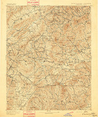
~ Cranberry NC topo map, 1:125000 scale, 30 X 30 Minute, Historical, 1893
Cranberry, North Carolina, USGS topographic map dated 1893.
Includes geographic coordinates (latitude and longitude). This topographic map is suitable for hiking, camping, and exploring, or framing it as a wall map.
Printed on-demand using high resolution imagery, on heavy weight and acid free paper, or alternatively on a variety of synthetic materials.
Topos available on paper, Waterproof, Poly, or Tyvek. Usually shipping rolled, unless combined with other folded maps in one order.
- Product Number: USGS-5374922
- Free digital map download (high-resolution, GeoPDF): Cranberry, North Carolina (file size: 11 MB)
- Map Size: please refer to the dimensions of the GeoPDF map above
- Weight (paper map): ca. 55 grams
- Map Type: POD USGS Topographic Map
- Map Series: HTMC
- Map Verison: Historical
- Cell ID: 65285
- Scan ID: 161742
- Survey Year: 1892
- Datum: Unstated
- Map Projection: Unstated
- Map published by United States Geological Survey
- Map Language: English
- Scanner Resolution: 600 dpi
- Map Cell Name: Cranberry
- Grid size: 30 X 30 Minute
- Date on map: 1893
- Map Scale: 1:125000
- Geographical region: North Carolina, United States
Neighboring Maps:
All neighboring USGS topo maps are available for sale online at a variety of scales.
Spatial coverage:
Topo map Cranberry, North Carolina, covers the geographical area associated the following places:
- Peoria - Farthing (historical) - Sutherland - Penley (historical) - Green Valley - Leander - Meat Camp - Cranberry Gap - Hounds Ear - Triplett - Eastman (historical) - Moretz - Hemlock Ridge - Hughes - Sorrento Skies - Farmer Mill - Neva - Sweetwater - Toliver - Norwood Hollow - Poplar Grove - Sugar Mountain - Oak Grove - Buffalo Cove - North Fork - Minneapolis - Buck Mountain - Cloverhill Plantation - Crossnore - Heaton - Mabel - Rutherwood - Powderhorn Mountain - Buntontown - Beech Creek - Heath - Maple Grove - Linville - Brookside (historical) - Elk Mills - Osborn - Whaley - Pandora - Stump Knob (historical) - Walnut Grove - Bethel - Hodges Gap - Dougherty Heights - Pineola - Woodford - Boone Fork - Creston - Legerwood - Ski Mountain - Vilas - Parker - Fleetwood - Upton - Watauga Falls (historical) - Grandfather - Stamey Town - Laxon - Rominger - Kellerville - Sands - Jones (historical) - Echo Park - Montezuma - Grave Yard (historical) - The Forest at Blowing Rock - Mount Gilead - Mount Pleasant - Shulls Mill - Perkinsville - Willen Gap - Norris (historical) - Matney - Foscoe - Todd - Doeville - Green Hill - Roseborough - Bailey Camp - Mulberry - Maymead - Flat Springs - Sherwood - Falcon Crest - Red Tail Mountain - Newland - Cowanstown (historical) - Bamboo - Beech Mountain - Kelsey - Zionville - Clifton - Damascus - Apple Ridge - Norris - Warrensville
- Map Area ID: AREA36.536-82-81.5
- Northwest corner Lat/Long code: USGSNW36.5-82
- Northeast corner Lat/Long code: USGSNE36.5-81.5
- Southwest corner Lat/Long code: USGSSW36-82
- Southeast corner Lat/Long code: USGSSE36-81.5
- Northern map edge Latitude: 36.5
- Southern map edge Latitude: 36
- Western map edge Longitude: -82
- Eastern map edge Longitude: -81.5


