
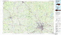
~ Winston Salem NC topo map, 1:100000 scale, 30 X 60 Minute, Historical, 1984, updated 1985
Winston Salem, North Carolina, USGS topographic map dated 1984.
Includes geographic coordinates (latitude and longitude). This topographic map is suitable for hiking, camping, and exploring, or framing it as a wall map.
Printed on-demand using high resolution imagery, on heavy weight and acid free paper, or alternatively on a variety of synthetic materials.
Topos available on paper, Waterproof, Poly, or Tyvek. Usually shipping rolled, unless combined with other folded maps in one order.
- Product Number: USGS-5374878
- Free digital map download (high-resolution, GeoPDF): Winston Salem, North Carolina (file size: 24 MB)
- Map Size: please refer to the dimensions of the GeoPDF map above
- Weight (paper map): ca. 55 grams
- Map Type: POD USGS Topographic Map
- Map Series: HTMC
- Map Verison: Historical
- Cell ID: 68609
- Scan ID: 161818
- Imprint Year: 1985
- Woodland Tint: Yes
- Aerial Photo Year: 1980
- Edit Year: 1984
- Datum: NAD27
- Map Projection: Universal Transverse Mercator
- Planimetric: Yes
- Map published by United States Geological Survey
- Map Language: English
- Scanner Resolution: 600 dpi
- Map Cell Name: Winston-Salem
- Grid size: 30 X 60 Minute
- Date on map: 1984
- Map Scale: 1:100000
- Geographical region: North Carolina, United States
Neighboring Maps:
All neighboring USGS topo maps are available for sale online at a variety of scales.
Spatial coverage:
Topo map Winston Salem, North Carolina, covers the geographical area associated the following places:
- Mountain Park - Long Hill - Mulberry - Vienna - Park Terrace - Flat Shoals - New Home (historical) - Dorchester - Windsors Crossroads - Sugartown - Skyview Park - Arlington - Union Cross - Lewisville Trails - Lewisville - Hamptonville - Macedonia - Four Seasons - Wyo - Dobson - Poplar Springs - West Salem - Farmington - Waughtown - Zion (historical) - Dennis - Forest Hills - Elkin - Creekwood Acres - Hills Grove - Marler - Quail Hollow - Johnstown - Yorktown - Chestnut Trails - Oak Grove - Pine Hall - Glennwood Acres - Baltimore - Rosemont - Talleys Crossing - Applegate - Union Grove - Salem - Union Hill - Ogburn Station - Cutters Creek - Pea Ridge - Pfafftown - Prestonville - Quaker Gap - Roaring Gap - Siloam - Woodbridge - Robinhood Forest - Columbia Heights - West Oaks - Grapewood - Jennings - Guthrie - Forbush - Smithtown - Sheltontown - Reynolda - Five Points - Frontis - Alspaugh - Bon Air - Moores Springs - Little Richmond - North Winston - Bannertown - River Ridge Run - Willowbend - Ceramic (historical) - Yadkinville - Somers Crossroads - Mount Tabor - Thurmond - Glen High Estates - Christy Acres - Poplar Springs - Union Cross - Wallburg - Jonestown - Zephyr - Dan River Shores - Baileytown - Fulp - Pebble Creek Estates - Union Ridge - Osbornville - Dillard - Creekwood - Fox Hall - Zimmerman (historical) - Ardmore - Hillsdale - West Highlands - Atwood Acres
- Map Area ID: AREA36.536-81-80
- Northwest corner Lat/Long code: USGSNW36.5-81
- Northeast corner Lat/Long code: USGSNE36.5-80
- Southwest corner Lat/Long code: USGSSW36-81
- Southeast corner Lat/Long code: USGSSE36-80
- Northern map edge Latitude: 36.5
- Southern map edge Latitude: 36
- Western map edge Longitude: -81
- Eastern map edge Longitude: -80


