
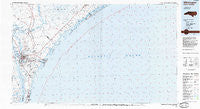
~ Wilmington NC topo map, 1:100000 scale, 30 X 60 Minute, Historical, 1984, updated 1985
Wilmington, North Carolina, USGS topographic map dated 1984.
Includes geographic coordinates (latitude and longitude). This topographic map is suitable for hiking, camping, and exploring, or framing it as a wall map.
Printed on-demand using high resolution imagery, on heavy weight and acid free paper, or alternatively on a variety of synthetic materials.
Topos available on paper, Waterproof, Poly, or Tyvek. Usually shipping rolled, unless combined with other folded maps in one order.
- Product Number: USGS-5374874
- Free digital map download (high-resolution, GeoPDF): Wilmington, North Carolina (file size: 28 MB)
- Map Size: please refer to the dimensions of the GeoPDF map above
- Weight (paper map): ca. 55 grams
- Map Type: POD USGS Topographic Map
- Map Series: HTMC
- Map Verison: Historical
- Cell ID: 68599
- Scan ID: 161794
- Imprint Year: 1985
- Aerial Photo Year: 1983
- Edit Year: 1984
- Datum: NAD27
- Map Projection: Universal Transverse Mercator
- Planimetric: Yes
- Map published by United States Geological Survey
- Map Language: English
- Scanner Resolution: 600 dpi
- Map Cell Name: Wilmington
- Grid size: 30 X 60 Minute
- Date on map: 1984
- Map Scale: 1:100000
- Geographical region: North Carolina, United States
Neighboring Maps:
All neighboring USGS topo maps are available for sale online at a variety of scales.
Spatial coverage:
Topo map Wilmington, North Carolina, covers the geographical area associated the following places:
- Lee Acres Mobile Home Park - Langleys Mobile Home Park Number 2 - Kimwood Mobile Home Park - Old Town - Hightsville - Mill Creek Mobile Home Park - Brown Town - Wrightsville - Kirkland - Marlboro - Woodside - Silver Lake - Arrowhead - Lions Gate - Melrose Mobile Home Park - Piner Mobile Home Park - Driftwood Mobile Home Park - Kings Landing - Kings Grant - Hampstead - Topsail - Millbrook - Wrightsboro Acres - Twin Oak - Queens Point - Glynnwood Mobile Home Park - Spring Oaks Mobile Home Estates - Bradley Creek East Estates - Wilmington - Grants Mobile Home Park - K and M Mobile Home Park - Double D Mobile Home Park - Silver Lake Mobile Home Park - Masonboro - Treasure Cove - Glen Meade - Sedgefield - Wrightsville Beach - Winter Park - Windemere - College Acres - Myrtle Grove - Long Leaf Acres - Shell Bank - South Oleander - Walnut Hills - Lincoln Forest - Greystone Estates - Princess Place - Parmele Isles - Westwood Heights - Southridge Mobile Home Park - Hanby Beach - Country Side Mobile Home Park - Royal Palms Mobile Home Park - The Palms Mobile Home Park - Barlowes - Timberland Village Mobile Home Park - Kendall Chapel - Greenville Village Mobile Home Park - North Topsail Beach - Delgado - Ponderosa Mobile Home Park - Sloop Point - Butler Mobile Home Community - Grove Park Mobile Home Estates - Camelot Mobile Park - Piney Woods - Powells Mobile Home Park - Richardsons Mobile Home Park - Sea Breeze - Alandale - Castle Hayne - Channel Acres - West Onslow Beach - Seagate - Clarks Landing - Wescott Mobile Home Community - Old Grove Mobile Home Park - Interstate Mobile Home Park - Mooretown - Marquis Hills - Edgecombe - Murraysville - Devon Park - Himobile Mobile Home Park - Hinsons Mobile Home Park - Wheel Estates Mobile Home Park - Wrightsboro - Scotts Hill - Clairmont - Oakley Mobile Home Park - Forest Hills - D and H Estates Mobile Home Park - Seitter Acres - Rosemans Mobile Home Park - Airlie - Oakcrest - Deerfield Mobile Home Park - Baldwin Estates Mobile Home Park
- Map Area ID: AREA34.534-78-77
- Northwest corner Lat/Long code: USGSNW34.5-78
- Northeast corner Lat/Long code: USGSNE34.5-77
- Southwest corner Lat/Long code: USGSSW34-78
- Southeast corner Lat/Long code: USGSSE34-77
- Northern map edge Latitude: 34.5
- Southern map edge Latitude: 34
- Western map edge Longitude: -78
- Eastern map edge Longitude: -77


