
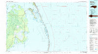
~ Manteo NC topo map, 1:100000 scale, 30 X 60 Minute, Historical, 1985, updated 1990
Manteo, North Carolina, USGS topographic map dated 1985.
Includes geographic coordinates (latitude and longitude). This topographic map is suitable for hiking, camping, and exploring, or framing it as a wall map.
Printed on-demand using high resolution imagery, on heavy weight and acid free paper, or alternatively on a variety of synthetic materials.
Topos available on paper, Waterproof, Poly, or Tyvek. Usually shipping rolled, unless combined with other folded maps in one order.
- Product Number: USGS-5374834
- Free digital map download (high-resolution, GeoPDF): Manteo, North Carolina (file size: 22 MB)
- Map Size: please refer to the dimensions of the GeoPDF map above
- Weight (paper map): ca. 55 grams
- Map Type: POD USGS Topographic Map
- Map Series: HTMC
- Map Verison: Historical
- Cell ID: 67903
- Scan ID: 161594
- Imprint Year: 1990
- Woodland Tint: Yes
- Aerial Photo Year: 1983
- Edit Year: 1985
- Datum: NAD27
- Map Projection: Universal Transverse Mercator
- Map published by United States Geological Survey
- Map Language: English
- Scanner Resolution: 600 dpi
- Map Cell Name: Manteo
- Grid size: 30 X 60 Minute
- Date on map: 1985
- Map Scale: 1:100000
- Geographical region: North Carolina, United States
Neighboring Maps:
All neighboring USGS topo maps are available for sale online at a variety of scales.
Spatial coverage:
Topo map Manteo, North Carolina, covers the geographical area associated the following places:
- Lake Neighborhood - Whalebone - Sound Side - Buffalo City - Stumpy Point - Mashoes - Wanchese - Beach Land Landing - Nags Head - Waves - Waves Landing - Uncle Jimmys Landing - South Rodanthe - Engelhard - Steeple - Roanoac (historical) - East Lake Landing - Salvo - Mother Vineyard - Sunny Side - Fort Raleigh City - Manteo - Manns Harbor - California - Lake Worth - Rodanthe - Baumtown - East Lake
- Map Area ID: AREA3635.5-76-75
- Northwest corner Lat/Long code: USGSNW36-76
- Northeast corner Lat/Long code: USGSNE36-75
- Southwest corner Lat/Long code: USGSSW35.5-76
- Southeast corner Lat/Long code: USGSSE35.5-75
- Northern map edge Latitude: 36
- Southern map edge Latitude: 35.5
- Western map edge Longitude: -76
- Eastern map edge Longitude: -75


