
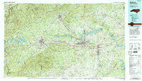
~ Hickory NC topo map, 1:100000 scale, 30 X 60 Minute, Historical, 1986, updated 1995
Hickory, North Carolina, USGS topographic map dated 1986.
Includes geographic coordinates (latitude and longitude). This topographic map is suitable for hiking, camping, and exploring, or framing it as a wall map.
Printed on-demand using high resolution imagery, on heavy weight and acid free paper, or alternatively on a variety of synthetic materials.
Topos available on paper, Waterproof, Poly, or Tyvek. Usually shipping rolled, unless combined with other folded maps in one order.
- Product Number: USGS-5374824
- Free digital map download (high-resolution, GeoPDF): Hickory, North Carolina (file size: 34 MB)
- Map Size: please refer to the dimensions of the GeoPDF map above
- Weight (paper map): ca. 55 grams
- Map Type: POD USGS Topographic Map
- Map Series: HTMC
- Map Verison: Historical
- Cell ID: 67666
- Scan ID: 162173
- Imprint Year: 1995
- Woodland Tint: Yes
- Visual Version Number: 1
- Aerial Photo Year: 1984
- Edit Year: 1986
- Datum: NAD27
- Map Projection: Universal Transverse Mercator
- Map published by United States Geological Survey
- Map Language: English
- Scanner Resolution: 600 dpi
- Map Cell Name: Hickory
- Grid size: 30 X 60 Minute
- Date on map: 1986
- Map Scale: 1:100000
- Geographical region: North Carolina, United States
Neighboring Maps:
All neighboring USGS topo maps are available for sale online at a variety of scales.
Spatial coverage:
Topo map Hickory, North Carolina, covers the geographical area associated the following places:
- North Lakes - Brevard (historical) - Mortimer - Pumpkin Center - Taylorsville Beach - Table Rock - Chambers (historical) - East Marion - Valmead - Cold Springs - Heritage Hills - Cat Square - Hampton Heights - Perkinsville - Indian Hills - Longtown - Three Mile - Henry - Stumptown - Copenhagen (historical) - Vashti - Duan - Rollins (historical) - Pine Mountain Lakes - Jonas Ridge - Adako - Icard - Oak Hill - Bradford Crossroads - Jacktown - Viewmont - Old Farm - New Home - Toluca - Fero - Trio (historical) - Bandy - Queens Acres - Blackburn - Patterson - Dudley Shoals - Hartland - Hardaway (historical) - Cooksville - Clinchfield - Chesterfield - Granville Terrace - Joyceton - Gamewell Heights - Fairway Acres - Cedar Valley - Granite Falls - Linville Falls - Taylorsville - Brindletown - Moores (historical) - Grace Chapel - Vein Mountain - Berkshire Hills - New Hope (historical) - Baird (historical) - Reepsville - Drums Crossroads - Vale - Saint Stephens - Pinehurst - Sawmills - Rufus - LeMar Park - Fairgrove - Burkemont - Liledoun - Petra Mills - Concord (historical) - North Cove - Advent Crossroads - Maiden - Bridgewater - Oakmont Estates - Rambling Acres - Mountain Home (historical) - Fairbrook - Sunrise Beach - Piney - Sharon - Drowning Creek (historical) - Nebo - Sweetwater - Draco - Altamont - Sycamore Acres - Ashford - Downsville (historical) - Drexel - Abingdon - Pineburr - Rutherford College - Flat Gap - Rhoney - Oxford Park
- Map Area ID: AREA3635.5-82-81
- Northwest corner Lat/Long code: USGSNW36-82
- Northeast corner Lat/Long code: USGSNE36-81
- Southwest corner Lat/Long code: USGSSW35.5-82
- Southeast corner Lat/Long code: USGSSE35.5-81
- Northern map edge Latitude: 36
- Southern map edge Latitude: 35.5
- Western map edge Longitude: -82
- Eastern map edge Longitude: -81


