
~ Hickory NC topo map, 1:100000 scale, 30 X 60 Minute, Historical, 1986, updated 1986
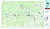
Hickory, North Carolina, USGS topographic map dated 1986.
Includes geographic coordinates (latitude and longitude). This topographic map is suitable for hiking, camping, and exploring, or framing it as a wall map.
Printed on-demand using high resolution imagery, on heavy weight and acid free paper, or alternatively on a variety of synthetic materials.
Topos available on paper, Waterproof, Poly, or Tyvek. Usually shipping rolled, unless combined with other folded maps in one order.
- Product Number: USGS-5374822
- Free digital map download (high-resolution, GeoPDF): Hickory, North Carolina (file size: 22 MB)
- Map Size: please refer to the dimensions of the GeoPDF map above
- Weight (paper map): ca. 55 grams
- Map Type: POD USGS Topographic Map
- Map Series: HTMC
- Map Verison: Historical
- Cell ID: 67666
- Scan ID: 162171
- Imprint Year: 1986
- Woodland Tint: Yes
- Aerial Photo Year: 1984
- Edit Year: 1986
- Datum: NAD27
- Map Projection: Universal Transverse Mercator
- Planimetric: Yes
- Map published by United States Geological Survey
- Map Language: English
- Scanner Resolution: 600 dpi
- Map Cell Name: Hickory
- Grid size: 30 X 60 Minute
- Date on map: 1986
- Map Scale: 1:100000
- Geographical region: North Carolina, United States
Neighboring Maps:
All neighboring USGS topo maps are available for sale online at a variety of scales.
Spatial coverage:
Topo map Hickory, North Carolina, covers the geographical area associated the following places:
- Jonas Ridge - Pinewood - Hardaway (historical) - Hatterbrond (historical) - Sycamore Acres - Petersburg - Laurel Hill - Oakmont Estates - Bethlehem - Concord (historical) - Drowning Creek (historical) - British Woods - Cooksville - New Home - Thermal City - Chambers (historical) - Glen Alpine - Maple Valley - Witherspoon Crossroad - Bradford Crossroads - Fero - Rufus - Killian Crossroads - Hickory - Amherst - Trio (historical) - Conover - Joyceton - Smokey Creek - Connelly Springs - Oak Hill - Queens Acres - Heritage Hills - Enola - Morganton - Hampton Heights - Fairgrove - Cedar Valley - Taylorsville Beach - Cold Springs - Petche Gap - Hildebran - Startown - Baton - Denver - Longview - Bandy - Tranquil Hill - Hibriten (historical) - Fairview Park - Camp Creek - Patterson - Isenhour Park - Cat Square - Emanuel (historical) - Vashti - Rambling Acres - Shoups Ford - Honey Hill - Piedmont Park Subdivision - Newton - Charlesmont - Altamont - Sardis (historical) - Seagles Store (historical) - Old Farm - Rocky Springs - Magnolia - Golden (historical) - Oxford Park - Fairbrook - LeMar Park - Moores (historical) - Warrior - Worry - Pineburr - Stumptown - Olivers Crossroads - Scotts - Rhodhiss - Murrays Hill - Claremont - Millersville - Casar - Cedar Rock Estates - Olive Grove - Providence Mill - Glenburine (historical) - Dysartsville - Rutherford College - Pinehurst - Mayfield - Linville River (historical) - Wisemans View - Patten - Midway - Pleasant Grove - Stony Point - Glenwood - Forest Hills
- Map Area ID: AREA3635.5-82-81
- Northwest corner Lat/Long code: USGSNW36-82
- Northeast corner Lat/Long code: USGSNE36-81
- Southwest corner Lat/Long code: USGSSW35.5-82
- Southeast corner Lat/Long code: USGSSE35.5-81
- Northern map edge Latitude: 36
- Southern map edge Latitude: 35.5
- Western map edge Longitude: -82
- Eastern map edge Longitude: -81


