
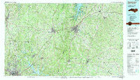
~ Henderson NC topo map, 1:100000 scale, 30 X 60 Minute, Historical, 1991, updated 1991
Henderson, North Carolina, USGS topographic map dated 1991.
Includes geographic coordinates (latitude and longitude). This topographic map is suitable for hiking, camping, and exploring, or framing it as a wall map.
Printed on-demand using high resolution imagery, on heavy weight and acid free paper, or alternatively on a variety of synthetic materials.
Topos available on paper, Waterproof, Poly, or Tyvek. Usually shipping rolled, unless combined with other folded maps in one order.
- Product Number: USGS-5374818
- Free digital map download (high-resolution, GeoPDF): Henderson, North Carolina (file size: 34 MB)
- Map Size: please refer to the dimensions of the GeoPDF map above
- Weight (paper map): ca. 55 grams
- Map Type: POD USGS Topographic Map
- Map Series: HTMC
- Map Verison: Historical
- Cell ID: 67660
- Scan ID: 162162
- Imprint Year: 1991
- Woodland Tint: Yes
- Visual Version Number: 2
- Aerial Photo Year: 1989
- Edit Year: 1991
- Datum: NAD27
- Map Projection: Universal Transverse Mercator
- Map published by United States Geological Survey
- Map Language: English
- Scanner Resolution: 600 dpi
- Map Cell Name: Henderson
- Grid size: 30 X 60 Minute
- Date on map: 1991
- Map Scale: 1:100000
- Geographical region: North Carolina, United States
Neighboring Maps:
All neighboring USGS topo maps are available for sale online at a variety of scales.
Spatial coverage:
Topo map Henderson, North Carolina, covers the geographical area associated the following places:
- Soul City - Marywood - Fairport - Parktown - Glen Forest - Franklinton - Willow Ridge - Floytan Crossroads - Triple Springs - Stallings Crossroads - Havenhill - Allensville - West Hills East - Bobbitt - Warren Plains - Fox Run - Letha (historical) - Greystone - Greymoss - Adcock Crossroads - Lickskillet - Church Hill - Bullocksville - Fieldstream - Denny Store - Bahama - West Hills - Satterwhite - Heather Glen - Huckleberry Spring - Louisburg - Bullock - Popes Crossroads - Cozart - Tar River - Needmore - Kinton Fork - Providence - Rocky Ford - Mill Grove - Roxboro - Wise - Westwood Hills - Quail Roost - Somerset - Weldons Mill - Dexter - Macon - Knotts Crossroads - Royal - Longhurst - Snow Hill - Surl - Redwood - Henderson - Country Place - Cornwall - Mount Tirzah - Horner - Oak Hill - Montwood - Island Creek Estates - Middleburg - Cokesbury - Kearney - Hickory Rock - Suntree - Knap of Reeds - Mount Energy - Gela - Centerville - Dickerson - Huntington Place - Ai - Schlosstown (historical) - Gillburg - Alert - Wilbourns - Vicksboro - Edwards Crossroads - Jacksontown - Faulkner Crossroads - Marmaduke - Vaughan - Grove Hill - Hebron - Berea - Hicks Crossroads - Mays Crossroads - Mangum Store - Lyons - Hampton - Moulton - Weaver - Greenwood Acres - University Estates - Stem - Townsville - Harris Crossroads - Creedmoor
- Map Area ID: AREA36.536-79-78
- Northwest corner Lat/Long code: USGSNW36.5-79
- Northeast corner Lat/Long code: USGSNE36.5-78
- Southwest corner Lat/Long code: USGSSW36-79
- Southeast corner Lat/Long code: USGSSE36-78
- Northern map edge Latitude: 36.5
- Southern map edge Latitude: 36
- Western map edge Longitude: -79
- Eastern map edge Longitude: -78


