
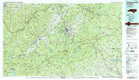
~ Hendersonville NC topo map, 1:100000 scale, 30 X 60 Minute, Historical, 1986, updated 1986
Hendersonville, North Carolina, USGS topographic map dated 1986.
Includes geographic coordinates (latitude and longitude). This topographic map is suitable for hiking, camping, and exploring, or framing it as a wall map.
Printed on-demand using high resolution imagery, on heavy weight and acid free paper, or alternatively on a variety of synthetic materials.
Topos available on paper, Waterproof, Poly, or Tyvek. Usually shipping rolled, unless combined with other folded maps in one order.
- Product Number: USGS-5374812
- Free digital map download (high-resolution, GeoPDF): Hendersonville, North Carolina (file size: 32 MB)
- Map Size: please refer to the dimensions of the GeoPDF map above
- Weight (paper map): ca. 55 grams
- Map Type: POD USGS Topographic Map
- Map Series: HTMC
- Map Verison: Historical
- Cell ID: 67662
- Scan ID: 162155
- Imprint Year: 1986
- Woodland Tint: Yes
- Visual Version Number: 1
- Aerial Photo Year: 1985
- Edit Year: 1986
- Datum: NAD27
- Map Projection: Universal Transverse Mercator
- Map published by United States Geological Survey
- Map published by Tennessee Valley Authority
- Map Language: English
- Scanner Resolution: 600 dpi
- Map Cell Name: Hendersonville
- Grid size: 30 X 60 Minute
- Date on map: 1986
- Map Scale: 1:100000
- Geographical region: North Carolina, United States
Neighboring Maps:
All neighboring USGS topo maps are available for sale online at a variety of scales.
Spatial coverage:
Topo map Hendersonville, North Carolina, covers the geographical area associated the following places:
- Willow Brook - Rosebud - Skyland - Ingleside - Selica - Mountain Valley - Burnt Chimney Corner - Mills River - Drysdale Hills - Hickory Hills - Liberia - Brickton - Barker Heights - Ecusta - Maxwell Mill - Grimesdale - Sedgewood - Seeshore - Hamilton Estates - Camp Occoneechee - O'Neal - Piney Woods - Fernwood - Peniel - Loehencove Ridge - Baxter - Nanney (historical) - Laurel Rock Acres - Penrose - Indian Lake Estates - Mill Spring - Franklin Park - Landrum - Bellvue - Patton Park - Hickory Hill - Ridgeview Estates - Deerwoods Estates - Brannons Store (historical) - Mill Corner - Tigerville - Bear Wallow Hollow - Still Meadows - Brookwood Trailer Park - Thomas Forest - Balsam Grove - Lavinia (historical) - Cedar Mountain - Falls Creek - Oak Hill - Broadview Estates - Ravenwood - East Fork - Midway - Avery Creek - Shumont - McCrary Acres - Druid Hills - Olga (historical) - Echo Acres - Springdale - Valley View Vistas - Willow Wew - Little Chicago - Mountain Home - Connestee Falls - New Prospect - Wolf Ford - Overlook - Hidden Valley - Dodd Hill - Illahee Hills - Quail Hollow - Cross Plains - Camelot - Timbercreek - Town Forest - Yale - Riverside Estates - Willow Wood - Sherwood Forest - Marydell (historical) - Busbee - Stone Brook - Green Hill - Knob Hill - Horace - Mack (historical) - Kanuga Park - Terrace Gardens - Valley Hill - Windor Hills - Blue Ridge Overlook - Hunter Crossing - Hoopers Creek - Little Africa - Lake Rugby - Campton - Tree Haven - Lake Lure
- Map Area ID: AREA35.535-83-82
- Northwest corner Lat/Long code: USGSNW35.5-83
- Northeast corner Lat/Long code: USGSNE35.5-82
- Southwest corner Lat/Long code: USGSSW35-83
- Southeast corner Lat/Long code: USGSSE35-82
- Northern map edge Latitude: 35.5
- Southern map edge Latitude: 35
- Western map edge Longitude: -83
- Eastern map edge Longitude: -82


