
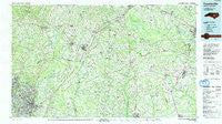
~ Fayetteville NC topo map, 1:100000 scale, 30 X 60 Minute, Historical, 1986, updated 1991
Fayetteville, North Carolina, USGS topographic map dated 1986.
Includes geographic coordinates (latitude and longitude). This topographic map is suitable for hiking, camping, and exploring, or framing it as a wall map.
Printed on-demand using high resolution imagery, on heavy weight and acid free paper, or alternatively on a variety of synthetic materials.
Topos available on paper, Waterproof, Poly, or Tyvek. Usually shipping rolled, unless combined with other folded maps in one order.
- Product Number: USGS-5374798
- Free digital map download (high-resolution, GeoPDF): Fayetteville, North Carolina (file size: 30 MB)
- Map Size: please refer to the dimensions of the GeoPDF map above
- Weight (paper map): ca. 55 grams
- Map Type: POD USGS Topographic Map
- Map Series: HTMC
- Map Verison: Historical
- Cell ID: 67512
- Scan ID: 161282
- Imprint Year: 1991
- Woodland Tint: Yes
- Aerial Photo Year: 1983
- Edit Year: 1986
- Datum: NAD27
- Map Projection: Universal Transverse Mercator
- Map published by United States Geological Survey
- Map Language: English
- Scanner Resolution: 600 dpi
- Map Cell Name: Fayetteville
- Grid size: 30 X 60 Minute
- Date on map: 1986
- Map Scale: 1:100000
- Geographical region: North Carolina, United States
Neighboring Maps:
All neighboring USGS topo maps are available for sale online at a variety of scales.
Spatial coverage:
Topo map Fayetteville, North Carolina, covers the geographical area associated the following places:
- Arran Lakes North - Kipling - Keener - Summer - Bataan - Montclair - Stradford Hills - Mar-Mac Village - Barclaysville - Spilona - Da-lin Mobile Home Park - McArthur Manor - Tranquil Acres - Oakland - Fairview Park - Clement - Twin Lakes - Red Hill - Brogden - Pleasant Acres Mobile Home Park - Bridle Creek - Mount Olive - Shawtown - Tokay - White Oaks Estates - Bordeaux - Hays Mill - Carver Heights - Erwin - Holiday Park - Bentonville - Lockwood - McKoy - Hermitage - Kornbow - Arran Lakes - Rebel City - Spiveys Corner - Hobbton - Fonville - Turlington - Mingo - South Haven - Timothy - Harnett - Lake Shores - Princeton - Harrington Mobile Home Park - Dobbersville - Northwood - Halls Crossroads - Blackmans Mills - Oak Forest - Southern Mobile Home Park - Brogden - Allens Crossroads - Eastover - Chestnut Hills - Sadie Heights - Clairway - Harper - Summertime - Woods Edge - Piney Green - Arran Hills - Norrington Crossroads - Dogwood Acres - Hillendale - Herrings Crossroads - Forest Hills - Midway - Wade - Overshot - Highland Acres - Bethany Crossroads - Buies Creek - Cooper - Waters Edge - Genoa - Anderson Creek - Cade Hill - East Fayetteville - Lafayette Park - South Goldsboro - Myrtle Hill - Mamers - Hollywood Heights - Talleywood - Stedman - Ascot II - Woodfield - Borden Heights - Newton Grove - Ardennes - Beard - Cottonade - Bunnlevel - Seabrook Hills - Country Club North - Howard Acres
- Map Area ID: AREA35.535-79-78
- Northwest corner Lat/Long code: USGSNW35.5-79
- Northeast corner Lat/Long code: USGSNE35.5-78
- Southwest corner Lat/Long code: USGSSW35-79
- Southeast corner Lat/Long code: USGSSE35-78
- Northern map edge Latitude: 35.5
- Southern map edge Latitude: 35
- Western map edge Longitude: -79
- Eastern map edge Longitude: -78


