
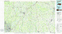
~ Fayetteville NC topo map, 1:100000 scale, 30 X 60 Minute, Historical, 1986, updated 1986
Fayetteville, North Carolina, USGS topographic map dated 1986.
Includes geographic coordinates (latitude and longitude). This topographic map is suitable for hiking, camping, and exploring, or framing it as a wall map.
Printed on-demand using high resolution imagery, on heavy weight and acid free paper, or alternatively on a variety of synthetic materials.
Topos available on paper, Waterproof, Poly, or Tyvek. Usually shipping rolled, unless combined with other folded maps in one order.
- Product Number: USGS-5374796
- Free digital map download (high-resolution, GeoPDF): Fayetteville, North Carolina (file size: 23 MB)
- Map Size: please refer to the dimensions of the GeoPDF map above
- Weight (paper map): ca. 55 grams
- Map Type: POD USGS Topographic Map
- Map Series: HTMC
- Map Verison: Historical
- Cell ID: 67512
- Scan ID: 161281
- Imprint Year: 1986
- Woodland Tint: Yes
- Aerial Photo Year: 1983
- Edit Year: 1986
- Datum: NAD27
- Map Projection: Universal Transverse Mercator
- Planimetric: Yes
- Map published by United States Geological Survey
- Map Language: English
- Scanner Resolution: 600 dpi
- Map Cell Name: Fayetteville
- Grid size: 30 X 60 Minute
- Date on map: 1986
- Map Scale: 1:100000
- Geographical region: North Carolina, United States
Neighboring Maps:
All neighboring USGS topo maps are available for sale online at a variety of scales.
Spatial coverage:
Topo map Fayetteville, North Carolina, covers the geographical area associated the following places:
- Yadkins Acres - Arran Lakes North - Peacocks Crossroads - Arran Lakes West - Kingsford - Heritage Heights - Forest Hills - Godwin - Bentonville - Rivercliff - Oak Forest - White Oaks Estates - Midway - Spring Hope - Greenwood Homes - Lake Valley - South Haven - Howard Acres - Westwood - Spring Lake - Scott Hills - Shaws - Benson - Reynolds Crossroads - Newton Grove - Broad Acres - Bizza Ridge - Glenhaven - Dunn - Poplar Grove - Buies Creek - Shadowlawn - Highland Village - Princeton - Shawtown - Queensdale - Lake Shores - Clement - South Goldsboro - Borden Heights - Rosin Hill - McArthur Manor - The Lakes - Cape Fear - Beaver Creek - Waters Edge - Robin Lake Estates - Brogden - Legion Park - Erwin - Pike Crossroads - Beautancus - Coats - Rebel City - Vann Crossroads - Suttontown - Hatcher - Bataan - Carlos - Anzio Acres - Timothy - Chestnut Hills - Lockwood - Lane - Foxfire - Starlight - Dobbersville - Fayetteville - Oakland - Stradford Hills - Stevens Mill - Allens Crossroads - Orange - Mar-Mac Village - Hillsdale - Luart - Harnett - Scotty Hills - Creeches Mill - Whitley Place - Brogden - Mamers - Boone Trail - Grantham - Green Valley Estates - Walkertown - Ardennes - Owens - Country Club North - South Hills - East Fayetteville - Lakecrest - Westover - Red Hill - Oakdale - Plain View - Broadell - Cooper - Rollingwood - Linden
- Map Area ID: AREA35.535-79-78
- Northwest corner Lat/Long code: USGSNW35.5-79
- Northeast corner Lat/Long code: USGSNE35.5-78
- Southwest corner Lat/Long code: USGSSW35-79
- Southeast corner Lat/Long code: USGSSE35-78
- Northern map edge Latitude: 35.5
- Southern map edge Latitude: 35
- Western map edge Longitude: -79
- Eastern map edge Longitude: -78


