
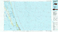
~ Currituck Sound NC topo map, 1:100000 scale, 30 X 60 Minute, Historical, 1985, updated 1990
Currituck Sound, North Carolina, USGS topographic map dated 1985.
Includes geographic coordinates (latitude and longitude). This topographic map is suitable for hiking, camping, and exploring, or framing it as a wall map.
Printed on-demand using high resolution imagery, on heavy weight and acid free paper, or alternatively on a variety of synthetic materials.
Topos available on paper, Waterproof, Poly, or Tyvek. Usually shipping rolled, unless combined with other folded maps in one order.
- Product Number: USGS-5374788
- Free digital map download (high-resolution, GeoPDF): Currituck Sound, North Carolina (file size: 33 MB)
- Map Size: please refer to the dimensions of the GeoPDF map above
- Weight (paper map): ca. 55 grams
- Map Type: POD USGS Topographic Map
- Map Series: HTMC
- Map Verison: Historical
- Cell ID: 67375
- Scan ID: 161172
- Imprint Year: 1990
- Woodland Tint: Yes
- Aerial Photo Year: 1982
- Edit Year: 1985
- Datum: NAD27
- Map Projection: Universal Transverse Mercator
- Map published by United States Geological Survey
- Map Language: English
- Scanner Resolution: 600 dpi
- Map Cell Name: Currituck Sound
- Grid size: 30 X 60 Minute
- Date on map: 1985
- Map Scale: 1:100000
- Geographical region: North Carolina, United States
Neighboring Maps:
All neighboring USGS topo maps are available for sale online at a variety of scales.
Spatial coverage:
Topo map Currituck Sound, North Carolina, covers the geographical area associated the following places:
- Carolina Dunes - Barco - Croatan Shores - Ocean Hills - Point Harbor - Saltaire - Jay Crest - Coinjock - Avalon Bench - Kitty Hawk - Spot - Olds - Poteskeet Village - Gulls Flight - Sandy Ridge - Duck - Mamie - Shipswatch - Ocean Dunes - Snow Geese Dunes - Kitty Hawk Beach - Schooner Ridge - Port Trinitie - Walnut Island - Sanderling - Sea Ridge - Powells Point - Hargraves Bench - The Tides - Jarvisburg - Osprey - Corolla - Ocean Pines - Kill Devil Hills - Colington - Eagleton - North Point - Sand Dollar Shores - Grandy - Bertha - Bayberry Bluffs - Snow Geese South - Caffys Inlet Hamlet - Poyners Hill (historical) - Harbinger - Southern Shores - Poplar Branch - Aydlett - George Town Sands - Wild Duck Dunes - Tuckahoe - Sea Hawk - Waterlily
- Map Area ID: AREA36.536-76-75
- Northwest corner Lat/Long code: USGSNW36.5-76
- Northeast corner Lat/Long code: USGSNE36.5-75
- Southwest corner Lat/Long code: USGSSW36-76
- Southeast corner Lat/Long code: USGSSE36-75
- Northern map edge Latitude: 36.5
- Southern map edge Latitude: 36
- Western map edge Longitude: -76
- Eastern map edge Longitude: -75


