
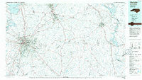
~ Charlotte NC topo map, 1:100000 scale, 30 X 60 Minute, Historical, 1985, updated 1986
Charlotte, North Carolina, USGS topographic map dated 1985.
Includes geographic coordinates (latitude and longitude). This topographic map is suitable for hiking, camping, and exploring, or framing it as a wall map.
Printed on-demand using high resolution imagery, on heavy weight and acid free paper, or alternatively on a variety of synthetic materials.
Topos available on paper, Waterproof, Poly, or Tyvek. Usually shipping rolled, unless combined with other folded maps in one order.
- Product Number: USGS-5374784
- Free digital map download (high-resolution, GeoPDF): Charlotte, North Carolina (file size: 20 MB)
- Map Size: please refer to the dimensions of the GeoPDF map above
- Weight (paper map): ca. 55 grams
- Map Type: POD USGS Topographic Map
- Map Series: HTMC
- Map Verison: Historical
- Cell ID: 67273
- Scan ID: 161084
- Imprint Year: 1986
- Aerial Photo Year: 1983
- Edit Year: 1985
- Datum: NAD27
- Map Projection: Universal Transverse Mercator
- Planimetric: Yes
- Map published by United States Geological Survey
- Map Language: English
- Scanner Resolution: 600 dpi
- Map Cell Name: Charlotte
- Grid size: 30 X 60 Minute
- Date on map: 1985
- Map Scale: 1:100000
- Geographical region: North Carolina, United States
Neighboring Maps:
All neighboring USGS topo maps are available for sale online at a variety of scales.
Spatial coverage:
Topo map Charlotte, North Carolina, covers the geographical area associated the following places:
- Planters Ridge - Colonial Village - Orchard Knoll - Roberta Mill - Richfield - Wildwood - Mint Hollow - Rama - Coulwood Hills - White Oak - Steelberry Acres - Lebanon Heights - Monteith (historical) - Robinson Church Community - Tuskasaga (historical) - Allen - Southminister Woods - Matthews Park - Montclaire South - Greenbriar Woods - Springhaven - Windrow Estates - Bosts Mill (historical) - Shady Brook - Fairfield - Caldwell - Settlers Landing - Hills - Reigate - Ashley Park - Devonshire - Ravenwood - Indian Trail - Clear Creek (historical) - Twelve Oaks - Kingswood - Rolling Hills - Pauls Crossing - Providence Park - Sharonbrook - Falcon Bridge - Forest Homes - Southbourne - Wilson Wood - Big Lick - Garden Park - Carmel Woods - Sunset Hills - Spicewood Acres - Grier Heights - Mountain Island - Uwharrie - Greenbriar - Stonehaven - Albemarle - Eldorado - Newell - Carowood - Holly Hills - Eden Gardens - Arlington - Severville - Mount Pleasant - Silverstone - Town Park - Shuffletown - Statewood - Frog Pond - Hope Farm - University Place - Pinecrest - Lockewood - Huntingtowne Farms - Red Cross - Providence (historical) - Watson - Thomasboro - Hemby Bridge - Old Orchid - Derita Woods - Joplor - Providence - Whispering Oaks - Rocky River - Bloomington - Olde Heritage - Hyde Park Estates - Mount Mitchell - Glenwood - Mountain Brook - Westbourne - New Salem - Cotswold - Eastover - Whiteville Park - Camp Cox - Oak Cliffs - Lake Park - Crater Park - Dixie
- Map Area ID: AREA35.535-81-80
- Northwest corner Lat/Long code: USGSNW35.5-81
- Northeast corner Lat/Long code: USGSNE35.5-80
- Southwest corner Lat/Long code: USGSSW35-81
- Southeast corner Lat/Long code: USGSSE35-80
- Northern map edge Latitude: 35.5
- Southern map edge Latitude: 35
- Western map edge Longitude: -81
- Eastern map edge Longitude: -80


