
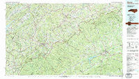
~ Boone NC topo map, 1:100000 scale, 30 X 60 Minute, Historical, 1985, updated 1986
Boone, North Carolina, USGS topographic map dated 1985.
Includes geographic coordinates (latitude and longitude). This topographic map is suitable for hiking, camping, and exploring, or framing it as a wall map.
Printed on-demand using high resolution imagery, on heavy weight and acid free paper, or alternatively on a variety of synthetic materials.
Topos available on paper, Waterproof, Poly, or Tyvek. Usually shipping rolled, unless combined with other folded maps in one order.
- Product Number: USGS-5374770
- Free digital map download (high-resolution, GeoPDF): Boone, North Carolina (file size: 33 MB)
- Map Size: please refer to the dimensions of the GeoPDF map above
- Weight (paper map): ca. 55 grams
- Map Type: POD USGS Topographic Map
- Map Series: HTMC
- Map Verison: Historical
- Cell ID: 67167
- Scan ID: 161955
- Imprint Year: 1986
- Woodland Tint: Yes
- Aerial Photo Year: 1984
- Edit Year: 1985
- Datum: NAD27
- Map Projection: Universal Transverse Mercator
- Map published by United States Geological Survey
- Map published by Tennessee Valley Authority
- Map Language: English
- Scanner Resolution: 600 dpi
- Map Cell Name: Boone
- Grid size: 30 X 60 Minute
- Date on map: 1985
- Map Scale: 1:100000
- Geographical region: North Carolina, United States
Neighboring Maps:
All neighboring USGS topo maps are available for sale online at a variety of scales.
Spatial coverage:
Topo map Boone, North Carolina, covers the geographical area associated the following places:
- Fishing Creek - Mertie (historical) - Dockery - Roten - Cilley (historical) - North Fork - Idlewild - Poplar Grove - Wilkesboro - Fletcher (historical) - Lovill - Smethport - Harley - Yadkin Valley - Hays Arbor - Gragg - Mill Ridge - Ferguson - Bamboo - Scottville - Toliver - Roseborough - Valley Creek - Woodford - Forest Hills - Brookwood - Ski Mountain - Perkinsville - Newland - Hemlock Ridge - Crackers Neck - Cloverhill Plantation - Ready Branch - Grandfather - Maple Grove - Valle Crucis - Farthing (historical) - Wagoner - Lomax - Buntontown - Quail Hollow Estates - Sherwood Forest - Spurgeon (historical) - Mount Pleasant - Reese - Bailey Camp - Pine Fork - Grave Yard (historical) - Lenoir (historical) - Hughes - Soda Hill - Oakwoods - Knollwood - Stokes (historical) - Cherry Lane - Knottville - Mountain Manor - Minneapolis - North Wilkesboro - Beech Mountain - Vale - Farmer Mill - Hodges Gap - Goulds (historical) - Red Tail Mountain - Boone - Whitehead - Mountain City - Brewers (historical) - Robinet (historical) - Ore Knob - Beaver Creek - Beaux (historical) - Henderson (historical) - Ironville (historical) - Cosfort (historical) - Peoria - Todd - Sutherland - Casper (historical) - Dry Hill - Midway - Leander - Country Club Hills - Abshers - Lansing - Hendrix (historical) - Purlear - Elk Park - Graybeal (historical) - Forest Grove - Pyatte - Norwood Hollow - Sherwood - Stump Knob (historical) - Green Valley - Othello - Apple Ridge - Chestnut Dale - Neva
- Map Area ID: AREA36.536-82-81
- Northwest corner Lat/Long code: USGSNW36.5-82
- Northeast corner Lat/Long code: USGSNE36.5-81
- Southwest corner Lat/Long code: USGSSW36-82
- Southeast corner Lat/Long code: USGSSE36-81
- Northern map edge Latitude: 36.5
- Southern map edge Latitude: 36
- Western map edge Longitude: -82
- Eastern map edge Longitude: -81


