
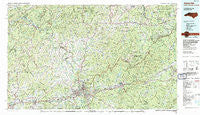
~ Asheville NC topo map, 1:100000 scale, 30 X 60 Minute, Historical, 1985, updated 1985
Asheville, North Carolina, USGS topographic map dated 1985.
Includes geographic coordinates (latitude and longitude). This topographic map is suitable for hiking, camping, and exploring, or framing it as a wall map.
Printed on-demand using high resolution imagery, on heavy weight and acid free paper, or alternatively on a variety of synthetic materials.
Topos available on paper, Waterproof, Poly, or Tyvek. Usually shipping rolled, unless combined with other folded maps in one order.
- Product Number: USGS-5374762
- Free digital map download (high-resolution, GeoPDF): Asheville, North Carolina (file size: 35 MB)
- Map Size: please refer to the dimensions of the GeoPDF map above
- Weight (paper map): ca. 55 grams
- Map Type: POD USGS Topographic Map
- Map Series: HTMC
- Map Verison: Historical
- Cell ID: 67066
- Scan ID: 161866
- Imprint Year: 1985
- Woodland Tint: Yes
- Visual Version Number: 2
- Aerial Photo Year: 1984
- Edit Year: 1985
- Datum: NAD27
- Map Projection: Universal Transverse Mercator
- Map published by United States Geological Survey
- Map Language: English
- Scanner Resolution: 600 dpi
- Map Cell Name: Asheville
- Grid size: 30 X 60 Minute
- Date on map: 1985
- Map Scale: 1:100000
- Geographical region: North Carolina, United States
Neighboring Maps:
All neighboring USGS topo maps are available for sale online at a variety of scales.
Spatial coverage:
Topo map Asheville, North Carolina, covers the geographical area associated the following places:
- Ivy - Buena Vista - Georgetown - Mount Mitchell - Beverly Hills - Candler - Gibsontown - Cane - Albemarle - Sandy Bottom - Stocksville - Teague (historical) - Bowlens Creek - Sayles Village - Palm (historical) - Toledo - Ingalls - Blue Rock - Paint Gap - Hillcrest Apts - Pine Spring - West Asheville - Hot Springs - Dendron - Cove - White Rock - Glady - Moffitt Hill - Alexander - Rollins - Clyde - Panther Creek - Stoney Knob - Knollwood - Bald Creek - Antioch - Blackberry Inn - Lynch (historical) - Osborne Knob - Lincoln Park - Rattlesnake Lodge - Owltown - Rolling Green - Swannanoa Hills - Paint Fork - Woodlawn - Minpro - Ridgecrest - Grovestone - Venable Community - Riverside - Greenlee - Ivy Ridge - Hankins - Azalea - Woolsey - Lee Walker Hots - Haw Creek - Toms Creek - Dogwood Grove - Wildacres - Bethel - Marion - Boonford - Hamrick - Sulphur Springs - Jupiter - Houston Valley - Craggy - Higgins - Trust - Spring Time - Shiloh - Sandymush - Concord - Davistown - Black Mountain - Terry Fork - Chapel Hill - Redmon - Hawk Branch - Fibreville - Bowditch - Stackhouse - Dula Springs - Murchison - Low Gap - Belva - Pensacola - Spruce Pine - North Cove Crossing - Bingham Heights - New Candler - Hawthorne - Paint Rock - Wing - Rockview - Deaver View - Summerhaven - Brooklawn Park
- Map Area ID: AREA3635.5-83-82
- Northwest corner Lat/Long code: USGSNW36-83
- Northeast corner Lat/Long code: USGSNE36-82
- Southwest corner Lat/Long code: USGSSW35.5-83
- Southeast corner Lat/Long code: USGSSE35.5-82
- Northern map edge Latitude: 36
- Southern map edge Latitude: 35.5
- Western map edge Longitude: -83
- Eastern map edge Longitude: -82


