
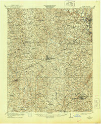
~ Lincolnton NC topo map, 1:62500 scale, 15 X 15 Minute, Historical, 1911, updated 1944
Lincolnton, North Carolina, USGS topographic map dated 1911.
Includes geographic coordinates (latitude and longitude). This topographic map is suitable for hiking, camping, and exploring, or framing it as a wall map.
Printed on-demand using high resolution imagery, on heavy weight and acid free paper, or alternatively on a variety of synthetic materials.
Topos available on paper, Waterproof, Poly, or Tyvek. Usually shipping rolled, unless combined with other folded maps in one order.
- Product Number: USGS-5374568
- Free digital map download (high-resolution, GeoPDF): Lincolnton, North Carolina (file size: 11 MB)
- Map Size: please refer to the dimensions of the GeoPDF map above
- Weight (paper map): ca. 55 grams
- Map Type: POD USGS Topographic Map
- Map Series: HTMC
- Map Verison: Historical
- Cell ID: 56739
- Scan ID: 162873
- Imprint Year: 1944
- Survey Year: 1909
- Datum: Unstated
- Map Projection: Polyconic
- Map published by United States Geological Survey
- Map Language: English
- Scanner Resolution: 600 dpi
- Map Cell Name: Lincolnton
- Grid size: 15 X 15 Minute
- Date on map: 1911
- Map Scale: 1:62500
- Geographical region: North Carolina, United States
Neighboring Maps:
All neighboring USGS topo maps are available for sale online at a variety of scales.
Spatial coverage:
Topo map Lincolnton, North Carolina, covers the geographical area associated the following places:
- Polkadot - Tryon - Bingham Bridge (historical) - Wilsonville (historical) - Light Oak - Carolina - Dora - Wilson (historical) - Flay - Vantine - Stony Point - Marys Grove - Holbrook - Cleveland Spring (historical) - Crouse - Hidden Valley - Landsdown - Waco - Orleans - New Prospect - White Pines - Laboratory - Elizabeth City - Cherryville - Fancy (historical) - Johnstown - Daniels (historical) - Baker Crossroads - Lincolnton - Dellview - Woodbridge - Bessemer City - Perry - Roseland - Sandy Plains - Stubbs - Oakgrove - North Brook (historical) - Sunnyside - Beam Mill
- Map Area ID: AREA35.535.25-81.5-81.25
- Northwest corner Lat/Long code: USGSNW35.5-81.5
- Northeast corner Lat/Long code: USGSNE35.5-81.25
- Southwest corner Lat/Long code: USGSSW35.25-81.5
- Southeast corner Lat/Long code: USGSSE35.25-81.25
- Northern map edge Latitude: 35.5
- Southern map edge Latitude: 35.25
- Western map edge Longitude: -81.5
- Eastern map edge Longitude: -81.25


