
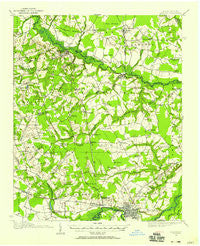
~ Kinston NC topo map, 1:62500 scale, 15 X 15 Minute, Historical, 1914, updated 1954
Kinston, North Carolina, USGS topographic map dated 1914.
Includes geographic coordinates (latitude and longitude). This topographic map is suitable for hiking, camping, and exploring, or framing it as a wall map.
Printed on-demand using high resolution imagery, on heavy weight and acid free paper, or alternatively on a variety of synthetic materials.
Topos available on paper, Waterproof, Poly, or Tyvek. Usually shipping rolled, unless combined with other folded maps in one order.
- Product Number: USGS-5374548
- Free digital map download (high-resolution, GeoPDF): Kinston, North Carolina (file size: 7 MB)
- Map Size: please refer to the dimensions of the GeoPDF map above
- Weight (paper map): ca. 55 grams
- Map Type: POD USGS Topographic Map
- Map Series: HTMC
- Map Verison: Historical
- Cell ID: 56222
- Scan ID: 162774
- Imprint Year: 1954
- Woodland Tint: Yes
- Visual Version Number: 1
- Survey Year: 1914
- Datum: NAD27
- Map Projection: Polyconic
- Map published by United States Geological Survey
- Map Language: English
- Scanner Resolution: 600 dpi
- Map Cell Name: Kinston
- Grid size: 15 X 15 Minute
- Date on map: 1914
- Map Scale: 1:62500
- Geographical region: North Carolina, United States
Neighboring Maps:
All neighboring USGS topo maps are available for sale online at a variety of scales.
Spatial coverage:
Topo map Kinston, North Carolina, covers the geographical area associated the following places:
- Tyndall Park - Georgetown - Sherwood Forest - Oak Lawn - Happersville (historical) - Heath - Foxtail Mobile Home Park - Sharon - Dawson - Falling Creek - Edgefield Forest - Howard Hights - Random Woods - Brentwood - Colonial Hights - George Washington Carver - Kinstonian Hights - Ormondsville - Kinfield Village - Greenmead - Liberty Hill Park - Country Club Estates - Fountain Hill - Graingers - County Acres - West haven - Glenfield - Hugo - Castle Oaks - Institute - Westwood - Briarwood Terrace - Kenwood Acres - Snow Hill - Branchwood - Hickory Hills - Hookerton - Pecan Grove Mobile Home Park - Perry Park - Wootens Crossroads - Savannah - Eastover - Fourway - Northview - Tower Heights - Mewborns Crossroads - Bynum Park - Trinity Woods - Club Pines - Arba - Grove Park - Tanglewood - Rolling Pines - Tarheel Courts - Kinston - Hardee Heights - Hillcrest Farms - Hullwood - Centennial Arms - Mount Vernon Park - Browntown Crossroads - Fields - Old Farm - Wheat Swamp - Hines Junction - Woods View - Glenfield Crossroads - Patsy Bran Mobile Home Park - Maury - Parrots - Rochelle Corners - Harveytown - County Square Estates - Hill View - Sleepy Fox Village Mobile Home Park - Lenoir Pines - Clubview - Kingwood Forest - Darewood Estates - Mobile Home Park - Lawarence Hights
- Map Area ID: AREA35.535.25-77.75-77.5
- Northwest corner Lat/Long code: USGSNW35.5-77.75
- Northeast corner Lat/Long code: USGSNE35.5-77.5
- Southwest corner Lat/Long code: USGSSW35.25-77.75
- Southeast corner Lat/Long code: USGSSE35.25-77.5
- Northern map edge Latitude: 35.5
- Southern map edge Latitude: 35.25
- Western map edge Longitude: -77.75
- Eastern map edge Longitude: -77.5


