
~ Sam Knob NC topo map, 1:24000 scale, 7.5 X 7.5 Minute, Historical, 1935
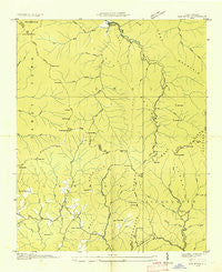
Sam Knob, North Carolina, USGS topographic map dated 1935.
Includes geographic coordinates (latitude and longitude). This topographic map is suitable for hiking, camping, and exploring, or framing it as a wall map.
Printed on-demand using high resolution imagery, on heavy weight and acid free paper, or alternatively on a variety of synthetic materials.
Topos available on paper, Waterproof, Poly, or Tyvek. Usually shipping rolled, unless combined with other folded maps in one order.
- Product Number: USGS-5373086
- Free digital map download (high-resolution, GeoPDF): Sam Knob, North Carolina (file size: 7 MB)
- Map Size: please refer to the dimensions of the GeoPDF map above
- Weight (paper map): ca. 55 grams
- Map Type: POD USGS Topographic Map
- Map Series: HTMC
- Map Verison: Historical
- Cell ID: 39549
- Scan ID: 164835
- Woodland Tint: Yes
- Field Check Year: 1935
- Datum: NAD27
- Map Projection: Polyconic
- Advance: Yes
- Planimetric: Yes
- Map published by Tennessee Valley Authority
- Map Language: English
- Scanner Resolution: 600 dpi
- Map Cell Name: Sam Knob
- Grid size: 7.5 X 7.5 Minute
- Date on map: 1935
- Map Scale: 1:24000
- Geographical region: North Carolina, United States
Neighboring Maps:
All neighboring USGS topo maps are available for sale online at a variety of scales.
Spatial coverage:
Topo map Sam Knob, North Carolina, covers the geographical area associated the following places:
- Rich Mountain Bald - Beetree Fork - Charley Bald - Devils Courthouse - Camp Two Branch - Wet Camp Gap - Cub Branch - Green Creek - Reinhart Gap - Little Bearpen Gap - Fire Scald Ridge - Spot Knob - Township of Cecil - Charley Knob - Brushy Ridge - Mount Hardy - Pinhook Gap - Kiesee Creek - Sam Branch - Bearpen Gap - Beech Gap - Herrin Knob - Balsam Lake - Haywood Gap Stream - Dill Falls - Rich Mountain - Hemlock Branch - Birdstand Mountain - Panther Branch - Shining Rock Creek - Charley Ridge - Richland Balsam - Yellow Patch Branch - Cathey Gap - Gage Ridge - Silvermine Bald - Charley Creek School - Great Balsam Mountains - Little Beartrap Ridge - Camp Mountain - Right Hand Prong West Fork Pigeon River - Mount Hardy Gap - Summey Cove - Green Knob - Buckeye Gap - Fork Ridge - Boomer Inn Branch - Rocky Knob - Buckeye Creek - Chestnut Ridge - Neddie Mountain - Sunburst Recreation Area - Richland Gap - Rocky Knob Gap - Cathey Ridge - Chestnut Creek - Coon Hollow - Beartrap Knob - Chestnut Bald - Sassafras Creek - Gage Creek - Bubbling Spring Branch - Courthouse Ridge - Horsebone Gap - Big Beartrail Ridge - Gage Gap - Big Fork Ridge - Courthouse Falls - Turnpike Creek - Haywood Gap - Sugar Cove - Camp Creek - Rocky Knob - Devil's Courthouse Tunnel - Mill Station Creek - Cold Creek - Deep Gap - Tanasee Bald - Bearpen Branch - Tom Creek - Raven Hollow - Flat Laurel Creek - Bald Knob Branch - Bryson Knob - Wolf Mountain - Gage Bald - Coalney Branch - Grassy Ridge Branch - Reinhart Knob - Courthouse Creek - Sam Knob - Possum Hollow - Black Mountain - Big Beartrap Branch - Parker Knob - Cold Spring Gap - Middle Prong Wilderness - Beartrail Ridge Gap - Buck Knob - Little Beartrap Branch
- Map Area ID: AREA35.37535.25-83-82.875
- Northwest corner Lat/Long code: USGSNW35.375-83
- Northeast corner Lat/Long code: USGSNE35.375-82.875
- Southwest corner Lat/Long code: USGSSW35.25-83
- Southeast corner Lat/Long code: USGSSE35.25-82.875
- Northern map edge Latitude: 35.375
- Southern map edge Latitude: 35.25
- Western map edge Longitude: -83
- Eastern map edge Longitude: -82.875


