
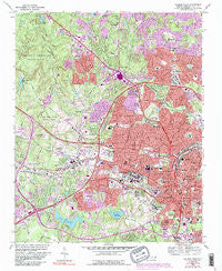
~ Raleigh West NC topo map, 1:24000 scale, 7.5 X 7.5 Minute, Historical, 1968, updated 1991
Raleigh West, North Carolina, USGS topographic map dated 1968.
Includes geographic coordinates (latitude and longitude). This topographic map is suitable for hiking, camping, and exploring, or framing it as a wall map.
Printed on-demand using high resolution imagery, on heavy weight and acid free paper, or alternatively on a variety of synthetic materials.
Topos available on paper, Waterproof, Poly, or Tyvek. Usually shipping rolled, unless combined with other folded maps in one order.
- Product Number: USGS-5372774
- Free digital map download (high-resolution, GeoPDF): Raleigh West, North Carolina (file size: 20 MB)
- Map Size: please refer to the dimensions of the GeoPDF map above
- Weight (paper map): ca. 55 grams
- Map Type: POD USGS Topographic Map
- Map Series: HTMC
- Map Verison: Historical
- Cell ID: 36946
- Scan ID: 163044
- Imprint Year: 1991
- Woodland Tint: Yes
- Visual Version Number: 2
- Photo Inspection Year: 1988
- Photo Revision Year: 1987
- Aerial Photo Year: 1984
- Edit Year: 1987
- Field Check Year: 1968
- Datum: NAD27
- Map Projection: Polyconic
- Map published by United States Geological Survey
- Map Language: English
- Scanner Resolution: 600 dpi
- Map Cell Name: Raleigh West
- Grid size: 7.5 X 7.5 Minute
- Date on map: 1968
- Map Scale: 1:24000
- Geographical region: North Carolina, United States
Neighboring Maps:
All neighboring USGS topo maps are available for sale online at a variety of scales.
Spatial coverage:
Topo map Raleigh West, North Carolina, covers the geographical area associated the following places:
- Ashley Park - Hayes Barton - Country Club Houses - Hunters Creek West - Anderson Heights - Old Farm - Stoneridge - Hinton - Caraleigh - Eden Forest - Meredith Townes - Fairview Acres - Asbury - Williamsburg Manor - Roylene Acres - Country Club Hills - Chestnut Hills - Isle Forest - Lambshire Downs - Brandermill - Oberlin - Glen Eden - Pineview Hills - Coley Forest - Georgetown - Wayne Ridge - Farrior Hills - Glenwood Village - Drewry Hills - Village Gate - Boylan Heights - Chippenhaven Square - Glen Forest - Briarcliff - North Haven - Kent Garden - North Hills - Fairmont - Wynnewood - Westover - Williamsborough - Edencroft - Lake Anne - Raleigh - Valley Estates - Lakestone - Scarsdale - Lakemont - Village on the Green - Beckana - Woodbury Village - Northclift - Budleigh - Birchwood Hills Estates - Fairfax Hills - Westchester - Indian Hills - Markwood - Walnut Ridge - Candero - Cedar Hills Estates - Kenmore - Hickory Hills - Walnut Terrace - Fairview Hills - Cameron Park - Pickwick Village - Thompson (historical) - North Hills Estates - Western Park - Bellevue Terrace - Northside - Yorkshire Downs - Deblyn Park - Medfield - Six Forks - Tysonville - Mount Vernon - Ridgeloch - West Raleigh - Sendero - Lakeside - Whitaker Park - Pines of Brookhaven - Northglen - Lynndale Estates - Ridgewood - Edgewood - Little Lake Hill - Royal Hills - North Hills Terrace - Orchards - Coley Lakes - Brookhaven - Country Life Estates - Method
- Map Area ID: AREA35.87535.75-78.75-78.625
- Northwest corner Lat/Long code: USGSNW35.875-78.75
- Northeast corner Lat/Long code: USGSNE35.875-78.625
- Southwest corner Lat/Long code: USGSSW35.75-78.75
- Southeast corner Lat/Long code: USGSSE35.75-78.625
- Northern map edge Latitude: 35.875
- Southern map edge Latitude: 35.75
- Western map edge Longitude: -78.75
- Eastern map edge Longitude: -78.625


