
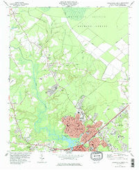
~ Jacksonville North NC topo map, 1:24000 scale, 7.5 X 7.5 Minute, Historical, 1978, updated 1978
Jacksonville North, North Carolina, USGS topographic map dated 1978.
Includes geographic coordinates (latitude and longitude). This topographic map is suitable for hiking, camping, and exploring, or framing it as a wall map.
Printed on-demand using high resolution imagery, on heavy weight and acid free paper, or alternatively on a variety of synthetic materials.
Topos available on paper, Waterproof, Poly, or Tyvek. Usually shipping rolled, unless combined with other folded maps in one order.
- Product Number: USGS-5371244
- Free digital map download (high-resolution, GeoPDF): Jacksonville North, North Carolina (file size: 12 MB)
- Map Size: please refer to the dimensions of the GeoPDF map above
- Weight (paper map): ca. 55 grams
- Map Type: POD USGS Topographic Map
- Map Series: HTMC
- Map Verison: Historical
- Cell ID: 22329
- Scan ID: 162720
- Imprint Year: 1978
- Woodland Tint: Yes
- Aerial Photo Year: 1974
- Edit Year: 1978
- Field Check Year: 1975
- Datum: NAD27
- Map Projection: Lambert Conformal Conic
- Map published by United States Geological Survey
- Map Language: English
- Scanner Resolution: 600 dpi
- Map Cell Name: Jacksonville North
- Grid size: 7.5 X 7.5 Minute
- Date on map: 1978
- Map Scale: 1:24000
- Geographical region: North Carolina, United States
Neighboring Maps:
All neighboring USGS topo maps are available for sale online at a variety of scales.
Spatial coverage:
Topo map Jacksonville North, North Carolina, covers the geographical area associated the following places:
- Westgate - Twin Pines Mobile Home Park - Shamrock Village - Edgewood Park - Gum Branch - Warrens Trailer Park - New River - Hillcrest Mobile Home Subdivision - Hickory Hills West Trailer Park - Oak Grove - Oakhurst River Estates - Stillwood - Greencrest - Sunset Acres - Brynn Marr - Long Acres - Half Moon Heights - Cardinal Village - Summersill Estates - Aldersgate - Houston Mobile Home Park - College Park - Foxhorn Village - Forest Grove - Raintree - Half Moon - Sherwood Forest - Bell Fork - Rainbow Acres Mobile Home Park - Greystone - Onslow Gardens - Acorn Forest - McArthur Estates - Hawkside - Willow Woods - Houston Heights - Jacksonville - Brookview Estates - Pine Forest Acres - Tar Landing - Faries Trailer Park - Branchwood - Indian Springs - Greenbriar - Northwoods Park - Town Ranch Heights - Lakewood - Lauradale - Cedar Creek - Deerfield - Morton Manor - Mill Pond Village - Bell Fork Homes - Mill Pond Meadows - Triangle Trailer Park
- Map Area ID: AREA34.87534.75-77.5-77.375
- Northwest corner Lat/Long code: USGSNW34.875-77.5
- Northeast corner Lat/Long code: USGSNE34.875-77.375
- Southwest corner Lat/Long code: USGSSW34.75-77.5
- Southeast corner Lat/Long code: USGSSE34.75-77.375
- Northern map edge Latitude: 34.875
- Southern map edge Latitude: 34.75
- Western map edge Longitude: -77.5
- Eastern map edge Longitude: -77.375


