
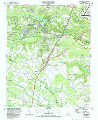
~ Hope Mills NC topo map, 1:24000 scale, 7.5 X 7.5 Minute, Historical, 1986, updated 1987
Hope Mills, North Carolina, USGS topographic map dated 1986.
Includes geographic coordinates (latitude and longitude). This topographic map is suitable for hiking, camping, and exploring, or framing it as a wall map.
Printed on-demand using high resolution imagery, on heavy weight and acid free paper, or alternatively on a variety of synthetic materials.
Topos available on paper, Waterproof, Poly, or Tyvek. Usually shipping rolled, unless combined with other folded maps in one order.
- Product Number: USGS-5371156
- Free digital map download (high-resolution, GeoPDF): Hope Mills, North Carolina (file size: 13 MB)
- Map Size: please refer to the dimensions of the GeoPDF map above
- Weight (paper map): ca. 55 grams
- Map Type: POD USGS Topographic Map
- Map Series: HTMC
- Map Verison: Historical
- Cell ID: 20962
- Scan ID: 162204
- Imprint Year: 1987
- Woodland Tint: Yes
- Aerial Photo Year: 1980
- Edit Year: 1986
- Field Check Year: 1981
- Datum: NAD27
- Map Projection: Lambert Conformal Conic
- Map published by United States Geological Survey
- Map Language: English
- Scanner Resolution: 600 dpi
- Map Cell Name: Hope Mills
- Grid size: 7.5 X 7.5 Minute
- Date on map: 1986
- Map Scale: 1:24000
- Geographical region: North Carolina, United States
Neighboring Maps:
All neighboring USGS topo maps are available for sale online at a variety of scales.
Spatial coverage:
Topo map Hope Mills, North Carolina, covers the geographical area associated the following places:
- Hope Mills - Clifton Forge - Eaglewood Forest - Ardulusa - McMillan - Colonial Heights - Pinewood Lakers - Timberlake - Roslin - Creekbend - Bonair Place - Southview Townhouses - Fairway Forest - Pinet Knoll - Stoney Point - Tanglewood Estates - Village Green - Golfer Acres - Pine Knoll - Riverview Estates - Decker Heights
- Map Area ID: AREA3534.875-79-78.875
- Northwest corner Lat/Long code: USGSNW35-79
- Northeast corner Lat/Long code: USGSNE35-78.875
- Southwest corner Lat/Long code: USGSSW34.875-79
- Southeast corner Lat/Long code: USGSSE34.875-78.875
- Northern map edge Latitude: 35
- Southern map edge Latitude: 34.875
- Western map edge Longitude: -79
- Eastern map edge Longitude: -78.875


