
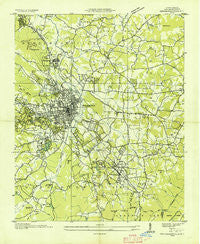
~ Hendersonville NC topo map, 1:24000 scale, 7.5 X 7.5 Minute, Historical, 1935
Hendersonville, North Carolina, USGS topographic map dated 1935.
Includes geographic coordinates (latitude and longitude). This topographic map is suitable for hiking, camping, and exploring, or framing it as a wall map.
Printed on-demand using high resolution imagery, on heavy weight and acid free paper, or alternatively on a variety of synthetic materials.
Topos available on paper, Waterproof, Poly, or Tyvek. Usually shipping rolled, unless combined with other folded maps in one order.
- Product Number: USGS-5370988
- Free digital map download (high-resolution, GeoPDF): Hendersonville, North Carolina (file size: 10 MB)
- Map Size: please refer to the dimensions of the GeoPDF map above
- Weight (paper map): ca. 55 grams
- Map Type: POD USGS Topographic Map
- Map Series: HTMC
- Map Verison: Historical
- Cell ID: 20093
- Scan ID: 162618
- Woodland Tint: Yes
- Field Check Year: 1935
- Datum: NAD27
- Map Projection: Polyconic
- Advance: Yes
- Map published by United States Geological Survey
- Map Language: English
- Scanner Resolution: 600 dpi
- Map Cell Name: Hendersonville
- Grid size: 7.5 X 7.5 Minute
- Date on map: 1935
- Map Scale: 1:24000
- Geographical region: North Carolina, United States
Neighboring Maps:
All neighboring USGS topo maps are available for sale online at a variety of scales.
Spatial coverage:
Topo map Hendersonville, North Carolina, covers the geographical area associated the following places:
- Mountain Home - Valley Hill - Stoney Mountain Estate - The Pines - Tranquility - Hendersonville - Lakewood - Camarian Estates - Upward - Kenwood Knolls - Laurel Park Villas - Windor Hills - Quail Ridge - Timberland - Terrace Gardens - Brookland Manor - Echo Lakes - Cannon Woods - Ravenwood - Lakeview Estates - Stoneycrest - Glenn Brook - Carolina Village - Hickory Hill - Echo Acres - Teneriffe - Kanuga Pines - Rosebud - Kingswood - Patton Park - Butt Mountain - Flat Rock Forest - Highland Hills - English Hills - Pinehurst - Oak Hill - Beaumont - Buckeye Ford - Holly Hill - Chanteloupe Country Estates - Mountain Lake Camp - Cumberland Village - Flat Rock - Cinnimon Woods - Woodhaven - Grimesdale - Country Acres - Westwood - Woodland Trace - Pebble Creek - Claremont - Willow Brook - Hillgirt - Town Forest - Essex - Cross William MHP - Brookdale - The Meadows - Five Points - East Flat Rock - Indian Hills - Willow Bend - Barker Heights - Bent Tree - Dana - Country Club Estates - U-No - Hillandale - Ridgeview Estates - Laurel Park - Balfour - Crooked Creek - Dellwood - Stone Brook - Willow Wew - Laurel Rock Acres - Plantation Walk - Overlook - Druid Hills
- Map Area ID: AREA35.37535.25-82.5-82.375
- Northwest corner Lat/Long code: USGSNW35.375-82.5
- Northeast corner Lat/Long code: USGSNE35.375-82.375
- Southwest corner Lat/Long code: USGSSW35.25-82.5
- Southeast corner Lat/Long code: USGSSE35.25-82.375
- Northern map edge Latitude: 35.375
- Southern map edge Latitude: 35.25
- Western map edge Longitude: -82.5
- Eastern map edge Longitude: -82.375


