
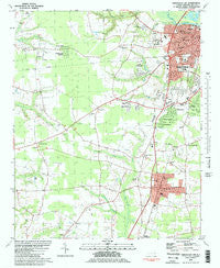
~ Greenville SW NC topo map, 1:24000 scale, 7.5 X 7.5 Minute, Historical, 1981, updated 1982
Greenville SW, North Carolina, USGS topographic map dated 1981.
Includes geographic coordinates (latitude and longitude). This topographic map is suitable for hiking, camping, and exploring, or framing it as a wall map.
Printed on-demand using high resolution imagery, on heavy weight and acid free paper, or alternatively on a variety of synthetic materials.
Topos available on paper, Waterproof, Poly, or Tyvek. Usually shipping rolled, unless combined with other folded maps in one order.
- Product Number: USGS-5370800
- Free digital map download (high-resolution, GeoPDF): Greenville SW, North Carolina (file size: 11 MB)
- Map Size: please refer to the dimensions of the GeoPDF map above
- Weight (paper map): ca. 55 grams
- Map Type: POD USGS Topographic Map
- Map Series: HTMC
- Map Verison: Historical
- Cell ID: 18471
- Scan ID: 162543
- Imprint Year: 1982
- Woodland Tint: Yes
- Visual Version Number: 1
- Aerial Photo Year: 1977
- Edit Year: 1981
- Field Check Year: 1978
- Datum: NAD27
- Map Projection: Lambert Conformal Conic
- Map published by United States Geological Survey
- Map Language: English
- Scanner Resolution: 600 dpi
- Map Cell Name: Greenville SW
- Grid size: 7.5 X 7.5 Minute
- Date on map: 1981
- Map Scale: 1:24000
- Geographical region: North Carolina, United States
Neighboring Maps:
All neighboring USGS topo maps are available for sale online at a variety of scales.
Spatial coverage:
Topo map Greenville SW, North Carolina, covers the geographical area associated the following places:
- Kearny Park - Candlewick Estates - Carolina Heights - Cannon Crossroads - Biltmore - Winterville - Renston - Oakdale - Greenbrier - Sedgefield - Robinson Heights - Sherwood Acres - Paige - Fairlane - Cambridge - Summerfield - Pinewood Forest - Riverdale - Treetops - Williamsburg Manor North - Weathington Heights - Baywood - Brentwood - Belvedere - Lynndale - Lakewood Pines - Frog Level - Rollingwood - Lake Ellsworth - Batts Court - Tucker Farms - Club Pines - Clevewood - Greenville Heights - Canterbury - Village Grove - Hillsdale - Willoughby Condominiums - Hines Crossroad - Dixons Crossroads - Lincoln Park - Bedford - Lincoln Park - Green Farm - Devonshire Square - Higgs - Red Oak - Greyleigh - Westhaven - Westwood - Evans Park - Rochdale - Shamrock Terrace
- Map Area ID: AREA35.62535.5-77.5-77.375
- Northwest corner Lat/Long code: USGSNW35.625-77.5
- Northeast corner Lat/Long code: USGSNE35.625-77.375
- Southwest corner Lat/Long code: USGSSW35.5-77.5
- Southeast corner Lat/Long code: USGSSE35.5-77.375
- Northern map edge Latitude: 35.625
- Southern map edge Latitude: 35.5
- Western map edge Longitude: -77.5
- Eastern map edge Longitude: -77.375


