
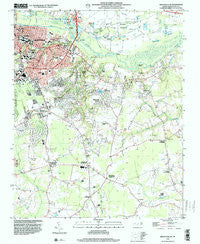
~ Greenville SE NC topo map, 1:24000 scale, 7.5 X 7.5 Minute, Historical, 1998, updated 2001
Greenville SE, North Carolina, USGS topographic map dated 1998.
Includes geographic coordinates (latitude and longitude). This topographic map is suitable for hiking, camping, and exploring, or framing it as a wall map.
Printed on-demand using high resolution imagery, on heavy weight and acid free paper, or alternatively on a variety of synthetic materials.
Topos available on paper, Waterproof, Poly, or Tyvek. Usually shipping rolled, unless combined with other folded maps in one order.
- Product Number: USGS-5370792
- Free digital map download (high-resolution, GeoPDF): Greenville SE, North Carolina (file size: 11 MB)
- Map Size: please refer to the dimensions of the GeoPDF map above
- Weight (paper map): ca. 55 grams
- Map Type: POD USGS Topographic Map
- Map Series: HTMC
- Map Verison: Historical
- Cell ID: 18466
- Scan ID: 162106
- Imprint Year: 2001
- Woodland Tint: Yes
- Aerial Photo Year: 1998
- Datum: NAD83
- Map Projection: Universal Transverse Mercator
- Map published by United States Geological Survey
- Map Language: English
- Scanner Resolution: 600 dpi
- Map Cell Name: Greenville SE
- Grid size: 7.5 X 7.5 Minute
- Date on map: 1998
- Map Scale: 1:24000
- Geographical region: North Carolina, United States
Neighboring Maps:
All neighboring USGS topo maps are available for sale online at a variety of scales.
Spatial coverage:
Topo map Greenville SE, North Carolina, covers the geographical area associated the following places:
- Hardee Acres - Drexelbrook - Jacksons Trailer Park - Hills Estate Mobile Home Park - Windsor - Baytree - Tuckahoe - Highland Mobile Home Park - Sheraton Place - Oakmont - Quail Ridge - River Hills - Galloway Crossroads - Brook Valley - Sherwood Greens - Tucker Estates - Windy Ridge - Arbor Hills - Brook Green - Forest Hills - Camelot - Golden Place - Green Springs - Greenville - Stratford - Brittany Ridge - Evans Mobile Home Park - Englewood - Edwards Acres - Coghill - Planters Walk - Wintergreen Mobile Home Park - Cox Crossing - Galloway Farms - Oakhurst - Evans Trailer Park - New Belden - Rolling Meadows - Chatham Circle - College Court - Hartington and Williams - Cherry Oaks - McGowans Crossroads - Paramore Farm - Simpson - Lake Glenwood - Scarborough - Hudsons Crossroads - Speight - Wilson Acres - Johnston Heights - Ripple City - Alvah Hardy Jr Mobile Home Park - Rock Springs - Easthaven - Greystone Mobile Home Park - College View - Heritage Village - Twin Creek - Worthingtons Crossroads - Dellwood - Hollywood Crossroads - Highland Mobile Home Park - Gold Leaf Estates - Eastwood - Azalea Gardens Mobile Home Park - Bell Fork
- Map Area ID: AREA35.62535.5-77.375-77.25
- Northwest corner Lat/Long code: USGSNW35.625-77.375
- Northeast corner Lat/Long code: USGSNE35.625-77.25
- Southwest corner Lat/Long code: USGSSW35.5-77.375
- Southeast corner Lat/Long code: USGSSE35.5-77.25
- Northern map edge Latitude: 35.625
- Southern map edge Latitude: 35.5
- Western map edge Longitude: -77.375
- Eastern map edge Longitude: -77.25


