
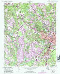
~ Fayetteville NC topo map, 1:24000 scale, 7.5 X 7.5 Minute, Historical, 1957, updated 1987
Fayetteville, North Carolina, USGS topographic map dated 1957.
Includes geographic coordinates (latitude and longitude). This topographic map is suitable for hiking, camping, and exploring, or framing it as a wall map.
Printed on-demand using high resolution imagery, on heavy weight and acid free paper, or alternatively on a variety of synthetic materials.
Topos available on paper, Waterproof, Poly, or Tyvek. Usually shipping rolled, unless combined with other folded maps in one order.
- Product Number: USGS-5370406
- Free digital map download (high-resolution, GeoPDF): Fayetteville, North Carolina (file size: 18 MB)
- Map Size: please refer to the dimensions of the GeoPDF map above
- Weight (paper map): ca. 55 grams
- Map Type: POD USGS Topographic Map
- Map Series: HTMC
- Map Verison: Historical
- Cell ID: 15098
- Scan ID: 161284
- Imprint Year: 1987
- Woodland Tint: Yes
- Photo Revision Year: 1987
- Aerial Photo Year: 1984
- Edit Year: 1987
- Field Check Year: 1957
- Datum: NAD27
- Map Projection: Polyconic
- Map published by United States Army Corps of Engineers
- Map Language: English
- Scanner Resolution: 600 dpi
- Map Cell Name: Fayetteville
- Grid size: 7.5 X 7.5 Minute
- Date on map: 1957
- Map Scale: 1:24000
- Geographical region: North Carolina, United States
Neighboring Maps:
All neighboring USGS topo maps are available for sale online at a variety of scales.
Spatial coverage:
Topo map Fayetteville, North Carolina, covers the geographical area associated the following places:
- Stradford Hills - Bonnie Doone - Arran Hills - Talleywood - Quail Ridge - Kirkwood - Arran Lakes West - Eccles Park - Westchester - Edenroc - Legion Park - Sherwood Park - Clairway - Crossgates - The Greens - Woodfield - Bordeaux - Woods Edge - Summertime - Tokay - Longview Acres - Eutaw - Lakecrest - Broad Acres - The Lakes - Breezewood Acres - Broadell - North Point Village - Oakdale - Huntington Park - Holiday Park - Pleasant Acres - Summer - Haymount - Holly Springs - Westwood - Bizza Ridge - Skibo - Queensdale - Hermitage - Oakland - Country Club North - Lakedale - Lake Shores - Fayetteville - Green Valley Estates - Foxfire - Phoenician Woods - McPherson Estates - Hillendale - South Hills - Glenhaven - Brentwood - Northwood - Seabrook Hills - Kingsford - Murray Hills - Cambridge - University Hills - University Estates - Lake Valley - Kornbow - Yadkins Acres - Vanstory Hills - Hollywood Heights - Glendale Acres - The Oaks - Woodlea - Warrenwood - Arran Lakes North - Belair - Shadowlawn - Evergreen Estates - Shaws - Greenwood Homes - Highland Village - Chestnut Hills - Montclair - Waters Edge - Myrtle Hill - Beaver Creek - Mayfair - Arran Lakes - Rollingwood - Bridle Creek - Vineland Park - Dogwood Acres - Winter Park - Shenandoah - Borden Heights - Crystal Park - Howard Acres - Lockwood - Forest Hills - Scotty Hills - Sadie Heights - Cumberland - Cottonade - Ducks Landing - Englewood
- Map Area ID: AREA35.12535-79-78.875
- Northwest corner Lat/Long code: USGSNW35.125-79
- Northeast corner Lat/Long code: USGSNE35.125-78.875
- Southwest corner Lat/Long code: USGSSW35-79
- Southeast corner Lat/Long code: USGSSE35-78.875
- Northern map edge Latitude: 35.125
- Southern map edge Latitude: 35
- Western map edge Longitude: -79
- Eastern map edge Longitude: -78.875


