
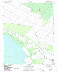
~ Engelhard West NC topo map, 1:24000 scale, 7.5 X 7.5 Minute, Historical, 1951, updated 1983
Engelhard West, North Carolina, USGS topographic map dated 1951.
Includes geographic coordinates (latitude and longitude). This topographic map is suitable for hiking, camping, and exploring, or framing it as a wall map.
Printed on-demand using high resolution imagery, on heavy weight and acid free paper, or alternatively on a variety of synthetic materials.
Topos available on paper, Waterproof, Poly, or Tyvek. Usually shipping rolled, unless combined with other folded maps in one order.
- Product Number: USGS-5370264
- Free digital map download (high-resolution, GeoPDF): Engelhard West, North Carolina (file size: 8 MB)
- Map Size: please refer to the dimensions of the GeoPDF map above
- Weight (paper map): ca. 55 grams
- Map Type: POD USGS Topographic Map
- Map Series: HTMC
- Map Verison: Historical
- Cell ID: 14382
- Scan ID: 161315
- Imprint Year: 1983
- Woodland Tint: Yes
- Photo Revision Year: 1983
- Aerial Photo Year: 1980
- Edit Year: 1983
- Field Check Year: 1951
- Survey Year: 1949
- Datum: NAD27
- Map Projection: Polyconic
- Map published by United States Department of Commerce
- Map Language: English
- Scanner Resolution: 600 dpi
- Map Cell Name: Engelhard West
- Grid size: 7.5 X 7.5 Minute
- Date on map: 1951
- Map Scale: 1:24000
- Geographical region: North Carolina, United States
Neighboring Maps:
All neighboring USGS topo maps are available for sale online at a variety of scales.
Spatial coverage:
Topo map Engelhard West, North Carolina, covers the geographical area associated the following places:
- Davis Elementary - Jarvis Canal - Engelhard Post Office - Fulford Cemetery - Pleasant Grove Church - Engelhard Volunteer Fire Department - Engelhard Census Designated Place
- Map Area ID: AREA35.62535.5-76.125-76
- Northwest corner Lat/Long code: USGSNW35.625-76.125
- Northeast corner Lat/Long code: USGSNE35.625-76
- Southwest corner Lat/Long code: USGSSW35.5-76.125
- Southeast corner Lat/Long code: USGSSE35.5-76
- Northern map edge Latitude: 35.625
- Southern map edge Latitude: 35.5
- Western map edge Longitude: -76.125
- Eastern map edge Longitude: -76


