
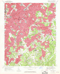
~ Charlotte East NC topo map, 1:24000 scale, 7.5 X 7.5 Minute, Historical, 1967, updated 1969
Charlotte East, North Carolina, USGS topographic map dated 1967.
Includes geographic coordinates (latitude and longitude). This topographic map is suitable for hiking, camping, and exploring, or framing it as a wall map.
Printed on-demand using high resolution imagery, on heavy weight and acid free paper, or alternatively on a variety of synthetic materials.
Topos available on paper, Waterproof, Poly, or Tyvek. Usually shipping rolled, unless combined with other folded maps in one order.
- Product Number: USGS-5369596
- Free digital map download (high-resolution, GeoPDF): Charlotte East, North Carolina (file size: 18 MB)
- Map Size: please refer to the dimensions of the GeoPDF map above
- Weight (paper map): ca. 55 grams
- Map Type: POD USGS Topographic Map
- Map Series: HTMC
- Map Verison: Historical
- Cell ID: 8228
- Scan ID: 164168
- Imprint Year: 1969
- Woodland Tint: Yes
- Aerial Photo Year: 1965
- Field Check Year: 1967
- Datum: NAD27
- Map Projection: Polyconic
- Map published by United States Geological Survey
- Map Language: English
- Scanner Resolution: 600 dpi
- Map Cell Name: Charlotte East
- Grid size: 7.5 X 7.5 Minute
- Date on map: 1967
- Map Scale: 1:24000
- Geographical region: North Carolina, United States
Neighboring Maps:
All neighboring USGS topo maps are available for sale online at a variety of scales.
Spatial coverage:
Topo map Charlotte East, North Carolina, covers the geographical area associated the following places:
- Providence Park - Dilworth - Chantilly - Hampton Leas - Woodberry Forest - Coventry Woods - Shannon Park - Carmel Woods - Starmount - Eastover - Singing Springs - North Charlotte - Barclay Downs - Spring Valley - Lockewood - Southpark - Eastfield - Sardis - Foxcroft - Sedgefield - Greenville - Sardis Oaks - Queens Grant - Sherwood Forest - Sharon Colony - Rosemont - Glenwood - Landsdowne - Pellyn Wood - Colonial Heights - Old Providence - Fox Run - Robinson Woods - Castleton Gardens - Beverly Woods - Selwyn Park - The Cloisters - Old Farm - Third Ward - Woodbridge - Providence Woods - Cotswold - Huntingtowne Farms - Elizabeth - Fourth Ward - Oakhurst - Windsor Park - Darby Acres - Villa Heights - Waverly Hall - Currituck - Wynnwood - Severville - Wilmore - Carmel - Montclaire - Olde Georgetowne - Bishops Ridge - Parkstone - Country Roads - Mountain Brook - Carmel Park - Belmont - Hebron (historical) - Biddleville - Old Salem - Beverly Woods East - Wesley Heights - Myers Park - Mayfair - Midwood - Sardis Cove - Charlotte - Cherry - Winterfield - Fairmeadows - Brandon - Stonehaven - Grier Heights - Olde Heritage - Rama - Parkview East
- Map Area ID: AREA35.2535.125-80.875-80.75
- Northwest corner Lat/Long code: USGSNW35.25-80.875
- Northeast corner Lat/Long code: USGSNE35.25-80.75
- Southwest corner Lat/Long code: USGSSW35.125-80.875
- Southeast corner Lat/Long code: USGSSE35.125-80.75
- Northern map edge Latitude: 35.25
- Southern map edge Latitude: 35.125
- Western map edge Longitude: -80.875
- Eastern map edge Longitude: -80.75


