
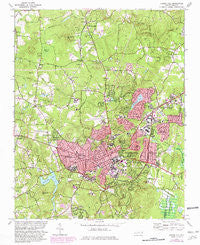
~ Chapel Hill NC topo map, 1:24000 scale, 7.5 X 7.5 Minute, Historical, 1978, updated 1982
Chapel Hill, North Carolina, USGS topographic map dated 1978.
Includes geographic coordinates (latitude and longitude). This topographic map is suitable for hiking, camping, and exploring, or framing it as a wall map.
Printed on-demand using high resolution imagery, on heavy weight and acid free paper, or alternatively on a variety of synthetic materials.
Topos available on paper, Waterproof, Poly, or Tyvek. Usually shipping rolled, unless combined with other folded maps in one order.
- Product Number: USGS-5369584
- Free digital map download (high-resolution, GeoPDF): Chapel Hill, North Carolina (file size: 15 MB)
- Map Size: please refer to the dimensions of the GeoPDF map above
- Weight (paper map): ca. 55 grams
- Map Type: POD USGS Topographic Map
- Map Series: HTMC
- Map Verison: Historical
- Cell ID: 8148
- Scan ID: 164163
- Imprint Year: 1982
- Woodland Tint: Yes
- Photo Revision Year: 1981
- Aerial Photo Year: 1980
- Edit Year: 1981
- Field Check Year: 1974
- Survey Year: 1946
- Datum: NAD27
- Map Projection: Lambert Conformal Conic
- Map published by United States Geological Survey
- Map Language: English
- Scanner Resolution: 600 dpi
- Map Cell Name: Chapel Hill
- Grid size: 7.5 X 7.5 Minute
- Date on map: 1978
- Map Scale: 1:24000
- Geographical region: North Carolina, United States
Neighboring Maps:
All neighboring USGS topo maps are available for sale online at a variety of scales.
Spatial coverage:
Topo map Chapel Hill, North Carolina, covers the geographical area associated the following places:
- Sedgefield - Colony Park - Birchwood Lake Estates - The Meadows - The Highlands - Coventry - Lake Forest Estates - The Oaks II - Estates Hills - Coker Hills - Timbercrest - Manor Hill - Calvander - Fox Meadows - Northwood - Spring Valley - Blackwood - Tenney Circle - Oak Hills - Carrboro - Briarcliff - Rangewood - Quail Run - Carolwoods - Glen Lennox - Stoney Brook - Mount Bolus - Pine Knob - Ridgefield Park - Hidden Hills - Davie Circle - Clark Hills - Farrington Hills - Morgan Creek Hills - Chapel Hill - Plantation Acres - Greenwood - Ironwoods - Laurel Springs - Lake Ellen - Lakewoods - Ashley Forest - Ridgefield - North Forest Hills - Kensington Trace - Summerfield Crossing - Carlton Acres - Eubanks - Dogwood Acres - Weatherhill - Stoneridge - Glen Heights - Colony Woods - The Woods at Laurel Hill - Elkins Hills - Wildwood Springs - High Park - Cedar Hill - Colonial Heights - Barrington Hills - Southbridge - Timberlyne - Robins Wood - Eastowne - The Oaks
- Map Area ID: AREA3635.875-79.125-79
- Northwest corner Lat/Long code: USGSNW36-79.125
- Northeast corner Lat/Long code: USGSNE36-79
- Southwest corner Lat/Long code: USGSSW35.875-79.125
- Southeast corner Lat/Long code: USGSSE35.875-79
- Northern map edge Latitude: 36
- Southern map edge Latitude: 35.875
- Western map edge Longitude: -79.125
- Eastern map edge Longitude: -79


