
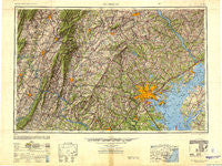
~ Baltimore MD topo map, 1:250000 scale, 1 X 2 Degree, Historical, 1948, updated 1948
Baltimore, Maryland, USGS topographic map dated 1948.
Includes geographic coordinates (latitude and longitude). This topographic map is suitable for hiking, camping, and exploring, or framing it as a wall map.
Printed on-demand using high resolution imagery, on heavy weight and acid free paper, or alternatively on a variety of synthetic materials.
Topos available on paper, Waterproof, Poly, or Tyvek. Usually shipping rolled, unless combined with other folded maps in one order.
- Product Number: USGS-5368736
- Free digital map download (high-resolution, GeoPDF): Baltimore, Maryland (file size: 17 MB)
- Map Size: please refer to the dimensions of the GeoPDF map above
- Weight (paper map): ca. 55 grams
- Map Type: POD USGS Topographic Map
- Map Series: HTMC
- Map Verison: Historical
- Cell ID: 74996
- Scan ID: 707209
- Imprint Year: 1948
- Woodland Tint: Yes
- Visual Version Number: 1
- Aerial Photo Year: 1944
- Datum: NAD27
- Map Projection: Transverse Mercator
- Shaded Relief map: Yes
- Map published by United States Army Corps of Engineers
- Map published by United States Army
- Map Language: English
- Scanner Resolution: 508 dpi
- Map Cell Name: Baltimore
- Grid size: 1 X 2 Degree
- Date on map: 1948
- Map Scale: 1:250000
- Geographical region: Maryland, United States
Neighboring Maps:
All neighboring USGS topo maps are available for sale online at a variety of scales.
Spatial coverage:
Topo map Baltimore, Maryland, covers the geographical area associated the following places:
- Meadows - Clearview - Monarch Meadow - Sandy Bottom - Old Home Estates - Pleasant Walk - Germantown Park - Cross Keys - Stoney Brook - Wolfsville Crossing - Wellington Woods - Diamond View - Crandon - Lewiston - Village of Peachwood - Brooks Hill - Carrs Store (historical) - Woodmoor - Morgan Park - Valentine Creek - Picketts Corner - Strathmore - Wilderness Walk - Pleasant View Estates - Kurtz Beach - Clearspring Manor - Holly Anna Acres - Worthington Run - Lineboro - Beacon View - Harrisonville - Cronhardt - Broadview Acres - Retreat Grove (historical) - Hammond Park - Larvadale Estates - Beaufort Park - Five Springs West - Woodlyn Heights - Seminary Springs - Stephen Knolls - Castle Oaks - Oakryn - Maplehurst Woods - Hedgesville - Edgewood View - Tuscarora Summit - Kelview - Valley View - Sharonville - Craigtown - Summerhill Park - Armistead Gardens - Ivy Hill - Twinridge - Piney Ridge Village - Copper Oaks - Terrace View Mobile Estates - Keyes Ferry Acres - Colonial Park - Foxborough Farms - Turf Valley - Sunnyside - Oakhurst - Nottingham Village - Velvet Hills - Longwood - Evergreen - Green Ridge - Liberty Lake Hills - Buttercup Estates - Lamb Knolls - Knoxlyn - Stonybrook Heights - Ferndale - Silo Hill - Buck Lodge - Gently Savage - Lester Acres - Everharts Crossroads - Hickory Hills - Rogers (historical) - Centerville - White Rock - Meredith Homes - Holbrook - Weyburn Park - Sewells Orchard - Stonegate Farms - Donney Brook Farms - Antietam Overlook - Ridge Grove - Mount Vernon - Swann Hills - Regency Estates - Daybreak Estates - West Laurel Acres - Harford Commons - Pembroke Knolls - Spickler
- Map Area ID: AREA4039-78-76
- Northwest corner Lat/Long code: USGSNW40-78
- Northeast corner Lat/Long code: USGSNE40-76
- Southwest corner Lat/Long code: USGSSW39-78
- Southeast corner Lat/Long code: USGSSE39-76
- Northern map edge Latitude: 40
- Southern map edge Latitude: 39
- Western map edge Longitude: -78
- Eastern map edge Longitude: -76


