
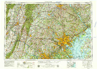
~ Baltimore MD topo map, 1:250000 scale, 1 X 2 Degree, Historical, 1957, updated 1979
Baltimore, Maryland, USGS topographic map dated 1957.
Includes geographic coordinates (latitude and longitude). This topographic map is suitable for hiking, camping, and exploring, or framing it as a wall map.
Printed on-demand using high resolution imagery, on heavy weight and acid free paper, or alternatively on a variety of synthetic materials.
Topos available on paper, Waterproof, Poly, or Tyvek. Usually shipping rolled, unless combined with other folded maps in one order.
- Product Number: USGS-5368732
- Free digital map download (high-resolution, GeoPDF): Baltimore, Maryland (file size: 29 MB)
- Map Size: please refer to the dimensions of the GeoPDF map above
- Weight (paper map): ca. 55 grams
- Map Type: POD USGS Topographic Map
- Map Series: HTMC
- Map Verison: Historical
- Cell ID: 74996
- Scan ID: 257767
- Imprint Year: 1979
- Woodland Tint: Yes
- Aerial Photo Year: 1976
- Edit Year: 1978
- Field Check Year: 1957
- Datum: Unstated
- Map Projection: Transverse Mercator
- Map published by United States Geological Survey
- Map Language: English
- Scanner Resolution: 600 dpi
- Map Cell Name: Baltimore
- Grid size: 1 X 2 Degree
- Date on map: 1957
- Map Scale: 1:250000
- Geographical region: Maryland, United States
Neighboring Maps:
All neighboring USGS topo maps are available for sale online at a variety of scales.
Spatial coverage:
Topo map Baltimore, Maryland, covers the geographical area associated the following places:
- Hunter Green - Highrock - Spring Lake Park - Magothy Forest - Woodville Meadows - Cedar Ridge - High Ridge - Fairview Acres - Richardsmere - Ariosa - Hannover - Urbanwood - Middleborough - Laurel Wood - Bunker Hill Estates - Oaklyn Manor - Warfield Estates - Croydon Park - Lewistown - Castleton - Sequoia - Silver Hill Farm - White Rock - Minefield - Oakland Park - Hawthorne - Sparks - Ivy Meadows - Owings Mills - Aylor - Tebbston - Hollywood Heights - Rosemont - Bradford Estates - Fremont Acres - Free Farms - Cedarwood Estates - Damascus - Locust Hill Estates - Sycolin - Spring Meadows - Patapsco - Shetland Hills - Flint - Highland - Television Hill - Cedar Acres - Linganore Woods - Confederate Hills - Capetowne - Olney Square - Gibralter Acres - Deerpark - Bartonsville - Harford Estates - Airville - Laurel Valley - Bonaparte Estates - Melanie Acres - Level - Goshen Hunt Estates - Ridgecrest - Drybranch - Colesville Park - Gaithersburg - Pleasant Estates - McKinsey Park - Rockview Beach - Wheatland - Marble Hill - Carriage Hill Village - Herman Heights - Singer - Hassengers Corner - Oakdale - Valley Heights - Verona - Clarksburg - Mechanic Grove - Meadows - Christophers Crossing - Unionville - Horse Shoe Farms Estates - Charles Manor - Conestoga Heights - Fairwood of Hunt Valley - Josenhans - Bacon Mill - Hartman - Shirley Manor - Coventry Farms - Covered Bridge Estates - Brookmead - Twin Oaks - Baltimore - Spring Valley Mobile Home Park - Pettebone Farms - Turf Valley Overlook - Jacobsville - Belmar Estates
- Map Area ID: AREA4039-78-76
- Northwest corner Lat/Long code: USGSNW40-78
- Northeast corner Lat/Long code: USGSNE40-76
- Southwest corner Lat/Long code: USGSSW39-78
- Southeast corner Lat/Long code: USGSSE39-76
- Northern map edge Latitude: 40
- Southern map edge Latitude: 39
- Western map edge Longitude: -78
- Eastern map edge Longitude: -76


