
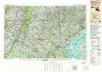
~ Baltimore MD topo map, 1:250000 scale, 1 X 2 Degree, Historical, 1989
Baltimore, Maryland, USGS topographic map dated 1989.
Includes geographic coordinates (latitude and longitude). This topographic map is suitable for hiking, camping, and exploring, or framing it as a wall map.
Printed on-demand using high resolution imagery, on heavy weight and acid free paper, or alternatively on a variety of synthetic materials.
Topos available on paper, Waterproof, Poly, or Tyvek. Usually shipping rolled, unless combined with other folded maps in one order.
- Product Number: USGS-5368722
- Free digital map download (high-resolution, GeoPDF): Baltimore, Maryland (file size: 29 MB)
- Map Size: please refer to the dimensions of the GeoPDF map above
- Weight (paper map): ca. 55 grams
- Map Type: POD USGS Topographic Map
- Map Series: HTMC
- Map Verison: Historical
- Cell ID: 74996
- Scan ID: 257762
- Woodland Tint: Yes
- Edit Year: 1989
- Datum: NAD83
- Map Projection: Universal Transverse Mercator
- Map published by United States Geological Survey
- Map Language: English
- Scanner Resolution: 600 dpi
- Map Cell Name: Baltimore
- Grid size: 1 X 2 Degree
- Date on map: 1989
- Map Scale: 1:250000
- Geographical region: Maryland, United States
Neighboring Maps:
All neighboring USGS topo maps are available for sale online at a variety of scales.
Spatial coverage:
Topo map Baltimore, Maryland, covers the geographical area associated the following places:
- Keeney Mill Farms - West Riding - Hamilton Park - Jerusalem Mills - Glenville - Barnett - Cascade - Cape McKinsey - Milestone - Wilimot Manor - Greenwood - Hartman - Forest Lawn - San Mar - Stonelake - Monocacy Meadows - College View - Rockland Estates - Brooklyn Manor - Fair Acres - Unison - Poplar Grove - Mansion House Manor - Koblan - Woodsdale - Ravenwood Estates - Beech Creek - Ridgewood Mobile Home Park - Highfield - Layhill South - Charing Cross - Silo Hill - Valley Meade - Rol-Park Trailer Village - Willson Hills - Nottinghamshire Farms - Susquehanna Hills - Oak Ridge Manor - Evna - England Estates - Colesville Heights - Indian Princess - Ivy Hill - Chestnut Oaks - Hi-View Estates - Franklinville - Calmes Neck Estates - Eastview Estates - Kings Town Manor - Glenmore - Kingston Heights - Jefferson Oaks - New Windsor - Gratitude - Le Gore - Edinburg Forest - Malvern - Staubs Thurmont Acres - Edmondson Village - Quail Run - Rosemount - Buck Lodge - Primrose Garth - Delta Heights - Twin Brook Estates - Happy Acres - Wilson Point - Walker Manor - Shetland Hills - Abingdon Reserve - Montpelier Woods - Sugarloaf Vista - Fairview - Avondale Run - Cheshaven - Longview Heights - Friendship Park - Orchard Point at Piney Orchard - Constant Friendship - Friendship - Ballenger Creek - Jefferson Heights - Claggettsville - Van Bibber Manor - Fort Deterick - Wyndham Hills - Mount Wilson - Bloomery - Chelsea of Nottingham - Sherwood Homes - Boydville - Northampton - Paradise - Glenbrook - Harford Heights - Twelve Trees - Louisville - Autumn Ridge - Saltworks on the Severn - Heidlersburg
- Map Area ID: AREA4039-78-76
- Northwest corner Lat/Long code: USGSNW40-78
- Northeast corner Lat/Long code: USGSNE40-76
- Southwest corner Lat/Long code: USGSSW39-78
- Southeast corner Lat/Long code: USGSSE39-76
- Northern map edge Latitude: 40
- Southern map edge Latitude: 39
- Western map edge Longitude: -78
- Eastern map edge Longitude: -76


