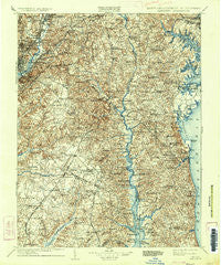
~ Patuxent MD topo map, 1:125000 scale, 30 X 30 Minute, Historical, 1906, updated 1934
Patuxent, Maryland, USGS topographic map dated 1906.
Includes geographic coordinates (latitude and longitude). This topographic map is suitable for hiking, camping, and exploring, or framing it as a wall map.
Printed on-demand using high resolution imagery, on heavy weight and acid free paper, or alternatively on a variety of synthetic materials.
Topos available on paper, Waterproof, Poly, or Tyvek. Usually shipping rolled, unless combined with other folded maps in one order.
- Product Number: USGS-5368688
- Free digital map download (high-resolution, GeoPDF): Patuxent, Maryland (file size: 13 MB)
- Map Size: please refer to the dimensions of the GeoPDF map above
- Weight (paper map): ca. 55 grams
- Map Type: POD USGS Topographic Map
- Map Series: HTMC
- Map Verison: Historical
- Cell ID: 66296
- Scan ID: 257744
- Imprint Year: 1934
- Survey Year: 1897
- Datum: Unstated
- Map Projection: Polyconic
- Map published by United States Geological Survey
- Map Language: English
- Scanner Resolution: 600 dpi
- Map Cell Name: Patuxent
- Grid size: 30 X 30 Minute
- Date on map: 1906
- Map Scale: 1:125000
- Geographical region: Maryland, United States
Neighboring Maps:
All neighboring USGS topo maps are available for sale online at a variety of scales.
Spatial coverage:
Topo map Patuxent, Maryland, covers the geographical area associated the following places:
- White Hall Forest - Brentwood - Summer City - Arbor Greene - Ashbox - Loves - Weems Creek - Marlow Heights - Bahama View - Franklin Manor-on-the-Bay - Morris Addition (historical) - Walnut Hills - Morgans Ridge - Victoria Estates - Heritage Harbour - Hollaway Estates - Mayo - Chaneyville Farm Estates - Buena Vista - Hanson Hills - Tobacco Woods - Harbor View - Holly Tree Park - Davidsonville Farmettes - Scientists Cliffs - Ivy City - Deer Crossing - Carrico Mill Estates - Hampton Heights - Bowie - Hardesty - Rest Haven - Oakbluff - Bay Ridge Junction - Chapel Oaks - Tranquility - Larkington - Pine Whiff Beach - Eagle Harbor - Hunting Lake - Boniwood - Greenwood Acres - Parkers Creek - Queens Chapel Manor - Villa Heights - Buena Vista Hills - Grays Estates - Marlton South - Wild Goose Landing - Temple Hills Park - Plainview Gardens - German Chapel Woods - Shipley Terrace - Acco Park - Fairmount Heights - Mayfair-Parkside - Green Acres - Century Estates - Pinefield - Brandywine Heights - Tantallon South - Pine Hill Estates - Woodyard - Lyons Creek Hundred - Fox Run - Cedar Run - Broadwater - Tyrol Estates - Lord Calvert Hills - Crofton Woods - Franklin Manor Beach - Kettering - Hunting Creek Woods - Quailwood - Mill Seat - Riva Trace - Pheasant Farm - Oak Hill Estates - Broadview - Middleton Farm - Clinton Woods - Boulevard Heights - Rolling Glen Farms - New Carrollton - Holland Cliff Shores - Cattertons Reach - Wildercroft - Springfield - Marlboro Hills - Pine Grove Estates - Peppermill Village - Springdale - Cedar Point - Holiday Beach - Annapolis Landing - North Deale - Michigan Park Hills - Harbor Hills - Chaneyville - Bellemead
- Map Area ID: AREA3938.5-77-76.5
- Northwest corner Lat/Long code: USGSNW39-77
- Northeast corner Lat/Long code: USGSNE39-76.5
- Southwest corner Lat/Long code: USGSSW38.5-77
- Southeast corner Lat/Long code: USGSSE38.5-76.5
- Northern map edge Latitude: 39
- Southern map edge Latitude: 38.5
- Western map edge Longitude: -77
- Eastern map edge Longitude: -76.5


