
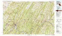
~ Cumberland MD topo map, 1:100000 scale, 30 X 60 Minute, Historical, 1981, updated 1982
Cumberland, Maryland, USGS topographic map dated 1981.
Includes geographic coordinates (latitude and longitude). This topographic map is suitable for hiking, camping, and exploring, or framing it as a wall map.
Printed on-demand using high resolution imagery, on heavy weight and acid free paper, or alternatively on a variety of synthetic materials.
Topos available on paper, Waterproof, Poly, or Tyvek. Usually shipping rolled, unless combined with other folded maps in one order.
- Product Number: USGS-5368626
- Free digital map download (high-resolution, GeoPDF): Cumberland, Maryland (file size: 40 MB)
- Map Size: please refer to the dimensions of the GeoPDF map above
- Weight (paper map): ca. 55 grams
- Map Type: POD USGS Topographic Map
- Map Series: HTMC
- Map Verison: Historical
- Cell ID: 67373
- Scan ID: 257705
- Imprint Year: 1982
- Woodland Tint: Yes
- Aerial Photo Year: 1977
- Edit Year: 1981
- Datum: NAD27
- Map Projection: Universal Transverse Mercator
- Map published by United States Geological Survey
- Map Language: English
- Scanner Resolution: 600 dpi
- Map Cell Name: Cumberland
- Grid size: 30 X 60 Minute
- Date on map: 1981
- Map Scale: 1:100000
- Geographical region: Maryland, United States
Neighboring Maps:
All neighboring USGS topo maps are available for sale online at a variety of scales.
Spatial coverage:
Topo map Cumberland, Maryland, covers the geographical area associated the following places:
- Lucas Heights - Lashley - Macdonaldton - Mount Trimble - Zihlman - Seymour - Barrelville - Mance - New Hope - Orleans Cross Roads - Horseshoe Curve - Hazen - Gilpin - Stanley - Spring Gap - Flintstone - Redrock Crossing - Picardy - Mann - Green Ridge - Artemas - Salco - Emerson - Breezy Point - Rawlings Heights - Lap - Mineral Spring - Little Cacapon - Potomac - Hays Mill - Goodtown - Kegg - East End - Indian Springs - Ernstville - Hancock - Johnsontown - Forest Park - Triple Lakes - Bowling Green - Fossilville - Jerome - Potomac Park - Sleepy Creek - Finzel - Dickeys Mountain - Great Cacapon - Buffalo Mills - Mountain Vistas - Crystal Spring - Spohrs Crossroads - Bittners Mill - National - Mench - New Baltimore - Knobmount - Gravel Pit - Bellegrove - Riverside (historical) - Midland - Burnt Factory - Carlos Junction - Needmore - Slabtown - Woodland - Mount Savage Junction - Mattie - Patterson Creek - Park Head - Johnsons Mill - Locust Grove - Stotlers Crossroads - Covalt - Millen - Gilmore - Marvania Heights - Lonaconing - Jackson Mills - Breezewood - Detmold - Brotherton - Glade City - Bedford Springs - Pine Hill - Wills Creek - Town Creek - Woodmont - Amcelle - Dogtown - Okonoko - McKenzie - Beegleton - Short Gap - Roundtop (historical) - South Cumberland - Purcell - Harvey - Shady Grove - Amcelle Acres - Vale Summit
- Map Area ID: AREA4039.5-79-78
- Northwest corner Lat/Long code: USGSNW40-79
- Northeast corner Lat/Long code: USGSNE40-78
- Southwest corner Lat/Long code: USGSSW39.5-79
- Southeast corner Lat/Long code: USGSSE39.5-78
- Northern map edge Latitude: 40
- Southern map edge Latitude: 39.5
- Western map edge Longitude: -79
- Eastern map edge Longitude: -78


