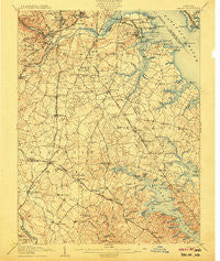
~ Relay MD topo map, 1:62500 scale, 15 X 15 Minute, Historical, 1907
Relay, Maryland, USGS topographic map dated 1907.
Includes geographic coordinates (latitude and longitude). This topographic map is suitable for hiking, camping, and exploring, or framing it as a wall map.
Printed on-demand using high resolution imagery, on heavy weight and acid free paper, or alternatively on a variety of synthetic materials.
Topos available on paper, Waterproof, Poly, or Tyvek. Usually shipping rolled, unless combined with other folded maps in one order.
- Product Number: USGS-5368506
- Free digital map download (high-resolution, GeoPDF): Relay, Maryland (file size: 10 MB)
- Map Size: please refer to the dimensions of the GeoPDF map above
- Weight (paper map): ca. 55 grams
- Map Type: POD USGS Topographic Map
- Map Series: HTMC
- Map Verison: Historical
- Cell ID: 61548
- Scan ID: 257646
- Survey Year: 1905
- Datum: Unstated
- Map Projection: Unstated
- Map published by United States Geological Survey
- Map Language: English
- Scanner Resolution: 600 dpi
- Map Cell Name: Relay
- Grid size: 15 X 15 Minute
- Date on map: 1907
- Map Scale: 1:62500
- Geographical region: Maryland, United States
Neighboring Maps:
All neighboring USGS topo maps are available for sale online at a variety of scales.
Spatial coverage:
Topo map Relay, Maryland, covers the geographical area associated the following places:
- Freetown Village - Millersville Forest - Canbury Woods - Stewart Corner - School Gardens - Solley Park - Quail Ridge - Masonville (historical) - Point Somerset - Severn Heights - Kings Heights - Rock Anna - Benton Terrace - Old Mill - Reece Heights - Lynnbrook - Belvoir Farms - Bonnie Acres - Round Bay - Wynnewood - Arundel Beach - Barrington Manor - Valentine Creek - Andorick Acres - Gatewater - Country Club Estates - Joyce - Hidden Hills - Severn Forest - Manhattan Manor - Rol-Park Trailer Village - Little John - Point Field Landing on the Severn - Elkridge Mobile Home Park - Spencer Gardens - Jacobsville - Lakeland - Grove Ridge - Dorsey - Glen Burnie Park - Foxhall Farm - Sweetser Heights - Mansion House Manor - Glen Hollow - Lipins Corner - Amberfield - Linthicum Hills - Villa Verdi - Chelsea Pines - Candlewood - Trinity Farms - Arundel Gardens - Deerfield - Stoney Hill - Derby Farms - Shipley Corner - Hillendale - Oakhill - Saefern - Pine Bluff - Solley Heights - Wethersfield - Brookfield - Fairoaks - Brightview Woods - Arundel Village - Windy Knolls - Provinces - Bohemia Beach - Lehigh - Pine Crest - Arbour Manor - Stoneybrook Village - Tall Timbers - Dreams Landing - Four Seasons Estates - Nottingham - Indian Creek Estates - Clear Water Beach - Silva-De-Amor - Ridgefield - Ramsgate News (not official) - Waterbury Heights - Cutler Ridge - Lansdowne - Michaelton Manor - Chesterfield Plaza - Riviera Isle - Brandon Shores - Glenmore - Woodcrest Gardens - Ferndale Manor - Orchard Point at Piney Orchard - Tydings - Strawberry Hills - Saltworks on the Severn - Harting Estates - Brooklyn Manor - Crestwood Mobile Home Park - The Dales
- Map Area ID: AREA39.2539-76.75-76.5
- Northwest corner Lat/Long code: USGSNW39.25-76.75
- Northeast corner Lat/Long code: USGSNE39.25-76.5
- Southwest corner Lat/Long code: USGSSW39-76.75
- Southeast corner Lat/Long code: USGSSE39-76.5
- Northern map edge Latitude: 39.25
- Southern map edge Latitude: 39
- Western map edge Longitude: -76.75
- Eastern map edge Longitude: -76.5


