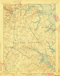
~ Relay MD topo map, 1:62500 scale, 15 X 15 Minute, Historical, 1894, updated 1901
Relay, Maryland, USGS topographic map dated 1894.
Includes geographic coordinates (latitude and longitude). This topographic map is suitable for hiking, camping, and exploring, or framing it as a wall map.
Printed on-demand using high resolution imagery, on heavy weight and acid free paper, or alternatively on a variety of synthetic materials.
Topos available on paper, Waterproof, Poly, or Tyvek. Usually shipping rolled, unless combined with other folded maps in one order.
- Product Number: USGS-5368502
- Free digital map download (high-resolution, GeoPDF): Relay, Maryland (file size: 8 MB)
- Map Size: please refer to the dimensions of the GeoPDF map above
- Weight (paper map): ca. 55 grams
- Map Type: POD USGS Topographic Map
- Map Series: HTMC
- Map Verison: Historical
- Cell ID: 61548
- Scan ID: 257644
- Imprint Year: 1901
- Survey Year: 1890
- Datum: Unstated
- Map Projection: Unstated
- Map published by United States Geological Survey
- Map Language: English
- Scanner Resolution: 600 dpi
- Map Cell Name: Relay
- Grid size: 15 X 15 Minute
- Date on map: 1894
- Map Scale: 1:62500
- Geographical region: Maryland, United States
Neighboring Maps:
All neighboring USGS topo maps are available for sale online at a variety of scales.
Spatial coverage:
Topo map Relay, Maryland, covers the geographical area associated the following places:
- Whitehurst - Ben Oaks - Hollywood - Orange Grove (historical) - Harwood Park - Stony Run - Hidden Hills - Rugby Hall Estates - Chelsea Pines - Laurel Acres - Oaks of Severna Park - Hickory Hills - Pine Bluff - Glenmore - Terrace View Mobile Estates - The Highlands - Lakewood - Old Glory Beach - Glen Burnie Park - Suburbia - Point Pleasant - Delmont - Shannon Square - Magothy Beach - West Dale Park - Tanager Forest - Howard Manor - Odenton Park - Arnold - Twin Harbors - Timberview - Longmeadow - Margate - Belvoir Farms - Arundel View - Kings Heights - Whitneys Landing - Kensington - Round Bay View - Indian Village - Sollers Point - Oakdale - Water Oak Point - Duffield - Homeland Park - Brooklyn Terrace - The Downs - Elkridge Heights - Twin Cove - Lake Riviera - Solley Park - Geraghty Village - Joyce - Warfield - Terrace Gardens - Cutler Ridge - Seaborne Estates - Villa Verdi - Country Club Estates - Stevenson Park - Arbour Manor - Bar Harbor Manor - Augusta Acres - Severnsides - Patuxent - Severn Ridge - Chartridge - Spencer Gardens - Sharonville - Meadow Brook - Chestnut Hill Cove - School Gardens - Manhattan Manor - Raynor Heights - Lynnbrook - Wethersfield - Magothy Forge - Pine Grove Village - Oakwood Manor - Woodlawn Heights - Gerard Plaza - Saltworks on the Severn - Foxhall Farm - Stony Beach - Water Oak Cove - Admiral (historical) - Allenville - English Consul - Leeds - Monumental - Winchester-on-the-Severn - Riverdale Forest - Charing Cross - Chartwell - Millhausens - Lark Hill - Beauty Beach - Selby Grove - Long Hill - Lombardee Beach
- Map Area ID: AREA39.2539-76.75-76.5
- Northwest corner Lat/Long code: USGSNW39.25-76.75
- Northeast corner Lat/Long code: USGSNE39.25-76.5
- Southwest corner Lat/Long code: USGSSW39-76.75
- Southeast corner Lat/Long code: USGSSE39-76.5
- Northern map edge Latitude: 39.25
- Southern map edge Latitude: 39
- Western map edge Longitude: -76.75
- Eastern map edge Longitude: -76.5


