
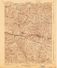
~ Mount Airy MD topo map, 1:62500 scale, 15 X 15 Minute, Historical, 1909, updated 1940
Mount Airy, Maryland, USGS topographic map dated 1909.
Includes geographic coordinates (latitude and longitude). This topographic map is suitable for hiking, camping, and exploring, or framing it as a wall map.
Printed on-demand using high resolution imagery, on heavy weight and acid free paper, or alternatively on a variety of synthetic materials.
Topos available on paper, Waterproof, Poly, or Tyvek. Usually shipping rolled, unless combined with other folded maps in one order.
- Product Number: USGS-5368334
- Free digital map download (high-resolution, GeoPDF): Mount Airy, Maryland (file size: 10 MB)
- Map Size: please refer to the dimensions of the GeoPDF map above
- Weight (paper map): ca. 55 grams
- Map Type: POD USGS Topographic Map
- Map Series: HTMC
- Map Verison: Historical
- Cell ID: 57931
- Scan ID: 257528
- Imprint Year: 1940
- Survey Year: 1907
- Datum: Unstated
- Map Projection: Polyconic
- Map published by United States Geological Survey
- Map Language: English
- Scanner Resolution: 600 dpi
- Map Cell Name: Mount Airy
- Grid size: 15 X 15 Minute
- Date on map: 1909
- Map Scale: 1:62500
- Geographical region: Maryland, United States
Neighboring Maps:
All neighboring USGS topo maps are available for sale online at a variety of scales.
Spatial coverage:
Topo map Mount Airy, Maryland, covers the geographical area associated the following places:
- Roxbury Mills - Woodville Terrace - Sweepstakes - Stone House Village - Piney Run Estates - Stonelake - Florence Estates - Kelly Ridge - New Port - Daisy - Ravenwood Estates - Treasure Mountain - Taylorsville - Gillis Falls Estates - Bartholows - Fair Wind Estates - Bennett Manor - McPherson - Olde Washington Valley - Mount Radnor Heights - Helliesen - Carroll Woods Estates - Christy Acres - Purdum - Eyre View - Hanford Estates - Bushey Heights - Elbeekay Farms - Davis - Highview - Dorceytown - Glenvue Acres - Langdon Woods - Buckhorn Run - Prospect View - Franklinville - Claggettsville - Merridale Gardens - Lisbon Meadows - Highview Estates - Chestnut Oaks - Ridgewood Estates - Molesworth Hills - Ridgely Estates - Kimberly Heights - West Oak Fields - Hickory Hill - Crampton - Cooksville - South Carroll Estates - Annapolis Rock - Quail Creek Acres - Cedar Heights Estates - Eagle Wood Estates - Candice Estates - Long Corner - Southview - Blankner Hill - Watersville - Mount Airy Estates - Park View Estates - Unionville - Damascus Manor - Pheasant Ridge Mobile Estates - Ray-Mar Estates - Bloom - Fox Ridge Estates - Fischer - Flag Marsh Heights - Tolley Terrace - Daisy Meadows - Carrs Mill - Potomac Estates - Silver Maple Estates - Ritter - Wild Lake Estates - Brantly - Kittyhawk Estates - Kabik Korner - Farmfield Estates - Silver Fern Estates - White Rock - Gosnell - Linganore Woods - Hipsleys Mill - Glenwood Estates - Airy Estates - Poignant Acres - Chases Forest - Seneca Overlook - Glisson Place - Poplar Springs - River Wood Hills - Rolling Hills - Gallagher Estates - Conestoga Heights - Carsan Knolls - Hungerford Manor - Buffalo Estates - Woodbine
- Map Area ID: AREA39.539.25-77.25-77
- Northwest corner Lat/Long code: USGSNW39.5-77.25
- Northeast corner Lat/Long code: USGSNE39.5-77
- Southwest corner Lat/Long code: USGSSW39.25-77.25
- Southeast corner Lat/Long code: USGSSE39.25-77
- Northern map edge Latitude: 39.5
- Southern map edge Latitude: 39.25
- Western map edge Longitude: -77.25
- Eastern map edge Longitude: -77


