
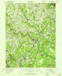
~ Laurel MD topo map, 1:62500 scale, 15 X 15 Minute, Historical, 1949, updated 1954
Laurel, Maryland, USGS topographic map dated 1949.
Includes geographic coordinates (latitude and longitude). This topographic map is suitable for hiking, camping, and exploring, or framing it as a wall map.
Printed on-demand using high resolution imagery, on heavy weight and acid free paper, or alternatively on a variety of synthetic materials.
Topos available on paper, Waterproof, Poly, or Tyvek. Usually shipping rolled, unless combined with other folded maps in one order.
- Product Number: USGS-5368290
- Free digital map download (high-resolution, GeoPDF): Laurel, Maryland (file size: 10 MB)
- Map Size: please refer to the dimensions of the GeoPDF map above
- Weight (paper map): ca. 55 grams
- Map Type: POD USGS Topographic Map
- Map Series: HTMC
- Map Verison: Historical
- Cell ID: 56580
- Scan ID: 257505
- Imprint Year: 1954
- Woodland Tint: Yes
- Aerial Photo Year: 1948
- Field Check Year: 1949
- Datum: NAD27
- Map Projection: Polyconic
- Map published by United States Geological Survey
- Map published by United States Army Corps of Engineers
- Map published by United States Army
- Map Language: English
- Scanner Resolution: 600 dpi
- Map Cell Name: Laurel
- Grid size: 15 X 15 Minute
- Date on map: 1949
- Map Scale: 1:62500
- Geographical region: Maryland, United States
Neighboring Maps:
All neighboring USGS topo maps are available for sale online at a variety of scales.
Spatial coverage:
Topo map Laurel, Maryland, covers the geographical area associated the following places:
- Fort George G Mead Junction - Laurel Wood - Wellington Estates - Greenwood Farms - Springbrook - Argonne Hills - Lillys Addition - Riverside - Hawthorn - Good Hope Estates - Oak Hill Estates - Savage - Guilford Square - Vantage Point - Boxwood Village - Tall Pines Trailer Park - Hollywood - Pfister Mobile Home Park - Crowder - Worthington - Pine Hill - Pheasant Run - Pine Valley - Wheatfield Way - Hillcrest Heights - Allview Estates - Stevens Forest - Rolling Acres - Leishear Village - Walker Hill - Knollwood - Forest Hills - Barbersville Trailer Park - Duckettsville - Brightfield - Montpelier Hills - Green Hill Manor - Aladdin Village Trailer Park - Edgewood - Rosemont - Twelve Hills - Mayfair - Castlegate - Orchard View - Monteith (historical) - Coon Manor - Dasher Green - Birchwood Gardens - Cedars - Northwest Park - Dayton - Sewells Orchard - Ashmead - Mistletoe Springs - New Birmingham Manor - Village of Dorseys Search - East Springbrook - Thompsons Purchase - Patuxent Riding - Homestead Estates - Brighton Pines - Fox Pause - North Ridge - Kings Meade - Clarksville Meadows - Wood Ridge - Maydale - Cabin Hill - La Isla - Pfeiffer Corners - Woodvalley - Villages of Montpelier - South Laurel - White Oak - Steward Manor - Burtonsville - Mill Grove Gardens - Knollview - Browns Corner - Oakland Mills - Simpson Woods - Oakview - Raintree Estates - Washington Manor Park - Cherrywood - Faulkner Ridge - Woodland Village - Hopewell - Wesley Grove - Clarksville - Hall Shop Estates - Huntington - Robeys Farmlets - Pines of Laurel - Stonewood - Snow Hill Manor - Smithville - Oxford Green - Locust Manor - Carole Acres
- Map Area ID: AREA39.2539-77-76.75
- Northwest corner Lat/Long code: USGSNW39.25-77
- Northeast corner Lat/Long code: USGSNE39.25-76.75
- Southwest corner Lat/Long code: USGSSW39-77
- Southeast corner Lat/Long code: USGSSE39-76.75
- Northern map edge Latitude: 39.25
- Southern map edge Latitude: 39
- Western map edge Longitude: -77
- Eastern map edge Longitude: -76.75


