
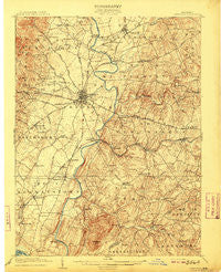
~ Ijamsville MD topo map, 1:62500 scale, 15 X 15 Minute, Historical, 1909
Ijamsville, Maryland, USGS topographic map dated 1909.
Includes geographic coordinates (latitude and longitude). This topographic map is suitable for hiking, camping, and exploring, or framing it as a wall map.
Printed on-demand using high resolution imagery, on heavy weight and acid free paper, or alternatively on a variety of synthetic materials.
Topos available on paper, Waterproof, Poly, or Tyvek. Usually shipping rolled, unless combined with other folded maps in one order.
- Product Number: USGS-5368254
- Free digital map download (high-resolution, GeoPDF): Ijamsville, Maryland (file size: 10 MB)
- Map Size: please refer to the dimensions of the GeoPDF map above
- Weight (paper map): ca. 55 grams
- Map Type: POD USGS Topographic Map
- Map Series: HTMC
- Map Verison: Historical
- Cell ID: 54378
- Scan ID: 257482
- Survey Year: 1907
- Datum: Unstated
- Map Projection: Unstated
- Map published by United States Geological Survey
- Map Language: English
- Scanner Resolution: 600 dpi
- Map Cell Name: Frederick
- Grid size: 15 X 15 Minute
- Date on map: 1909
- Map Scale: 1:62500
- Geographical region: Maryland, United States
Neighboring Maps:
All neighboring USGS topo maps are available for sale online at a variety of scales.
Spatial coverage:
Topo map Ijamsville, Maryland, covers the geographical area associated the following places:
- Shel-Mar Heights - Kingsley - Winter Run - Watkins Wilderness - Nightingale - Old Farm - Roberts Retreat - Double Tree Estates - Tranquility - West Hills - Hoot'N Hollow - Centerville - Clifton - Lewisdale - Harshman Estates - McKaig - Bloomfield - White Flint Springs - Hope Valley Hills - Daysville - Thurston - Amelano Manor - Sugarloaf Meadows - Lawrence - Riverwood - Denneys Delight - Flint Hill - Sweadner - Shookstown - Boyer Mill Heights - Sunnybrook Farms - Horse Shoe Farms Estates - Hilltop Woods - Sunny Acres - North Shore - Evergreen Point - New Market - Rock Creek Estates - Paulson - Fountain Rock Manor - Reels Mill - Chestnut Grove - Winter Springs - Pleasant Heights - Kidwiler Park - Pine Cliff - Henleys - Valley View - Burnt Hickory - Araby View - Doubs - Longview - Lilypons - New Market West - Hillview Acres - Gibralter Acres - Greenfield Mills - Farmbrook - Rolling Green - Arrowhead - Round Hill - Edgewood - Willowcrest - Lake Anita Louise - Park Mills - Fredericktowne Village - Clover Hill - Glade Manor - Yeager - Oakridge - Frederick Junction - Chadwick - Country Squire - Rosedale - Olacin - Brentwood - Woods - Scouts Knoll - View More Heights - Warfield - Greenfield Acres - Shookstown Heights - Sugarloaf Vista - Elliot - Tuscarora - Charlesville - Parkview Estates - High Barbaree - Grove Hill - Yellow Springs - Pleasant View - Brookmere Farms - Woodridge - Balmoral - Bootjack Springs Estates - Eyler Springs - Stockman - Silver Hill - Sanandrews - Village Estates
- Map Area ID: AREA39.539.25-77.5-77.25
- Northwest corner Lat/Long code: USGSNW39.5-77.5
- Northeast corner Lat/Long code: USGSNE39.5-77.25
- Southwest corner Lat/Long code: USGSSW39.25-77.5
- Southeast corner Lat/Long code: USGSSE39.25-77.25
- Northern map edge Latitude: 39.5
- Southern map edge Latitude: 39.25
- Western map edge Longitude: -77.5
- Eastern map edge Longitude: -77.25


