
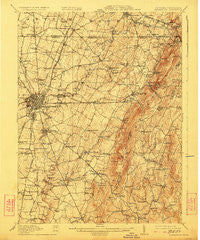
~ Hagerstown MD topo map, 1:62500 scale, 15 X 15 Minute, Historical, 1912, updated 1923
Hagerstown, Maryland, USGS topographic map dated 1912.
Includes geographic coordinates (latitude and longitude). This topographic map is suitable for hiking, camping, and exploring, or framing it as a wall map.
Printed on-demand using high resolution imagery, on heavy weight and acid free paper, or alternatively on a variety of synthetic materials.
Topos available on paper, Waterproof, Poly, or Tyvek. Usually shipping rolled, unless combined with other folded maps in one order.
- Product Number: USGS-5368218
- Free digital map download (high-resolution, GeoPDF): Hagerstown, Maryland (file size: 10 MB)
- Map Size: please refer to the dimensions of the GeoPDF map above
- Weight (paper map): ca. 55 grams
- Map Type: POD USGS Topographic Map
- Map Series: HTMC
- Map Verison: Historical
- Cell ID: 54978
- Scan ID: 257458
- Imprint Year: 1923
- Survey Year: 1910
- Datum: NAD
- Map Projection: Polyconic
- Map published by United States Geological Survey
- Map Language: English
- Scanner Resolution: 600 dpi
- Map Cell Name: Hagerstown
- Grid size: 15 X 15 Minute
- Date on map: 1912
- Map Scale: 1:62500
- Geographical region: Maryland, United States
Neighboring Maps:
All neighboring USGS topo maps are available for sale online at a variety of scales.
Spatial coverage:
Topo map Hagerstown, Maryland, covers the geographical area associated the following places:
- Highland - Country Squire Estates - Londontowne - Tilghmanton - Maugansville - Rouzerville - Midvale - Holiday Farms - Woodland Way - Wingerton - Frederick Manor - Antietam Farmettes - Green Hill Acres - Eldridge - Sunset Acres - Good Acres - Middle Creek Estates - Hopkins Ridge - Highland Woods - Paramount - Hunter Hill - Potomac Heights - Wolfsville - Beaver Creek Estates - Emmertsville - Burtner - Long Meadow - Spring Valley - Tilghmanton Heights - Lappans - Hagerstown - State Line - Bluegrass Estates - Church Hill Estates - Antietam Overlook - Highland Farms - Northridge Manor - El Rancho Mobile Home Park - North Lynch Estates - Chewsville - Blueberry Heights - Fairgreen Acres - Millpoint - Boonsboro - Hamilton Park - Wolfe - Wolfsville Crossing - Harp - Flook Farm - Fiddlesburg - Ringgold - Longview Estates - Holiday Acres - Beaver Creek - Doub Meadow - Cress - Edgemont - Smeltzer - Clearview - Fountain Head Heights - Eastland Hills - Garfield - Funkstown - Mapleville - Wagners Crossroads - Orchard Estates - Miller Chapel - Bagtown - Pleasant Valley - Pen Mar - Winding Creek South - Edgewood Hill - Pen Mar Park - Crestview - Security - Countryside - Waterloo - Doubs Mill - Orchard Hills - Northaven Mobile Home Park - Bowmans Mill - Five Forks - Trengail Manor - Jerusalem - Wistmans Delight - San Mar - Turkey Hill - June Acres - Fairplay - Reid - Lurose Estates - Colonial Park - Kinsey Heights - Cavetown - Green Hill - Hill Village - Bridgeport - Kline Mill - Pondsville - Blue Mountain
- Map Area ID: AREA39.7539.5-77.75-77.5
- Northwest corner Lat/Long code: USGSNW39.75-77.75
- Northeast corner Lat/Long code: USGSNE39.75-77.5
- Southwest corner Lat/Long code: USGSSW39.5-77.75
- Southeast corner Lat/Long code: USGSSE39.5-77.5
- Northern map edge Latitude: 39.75
- Southern map edge Latitude: 39.5
- Western map edge Longitude: -77.75
- Eastern map edge Longitude: -77.5


