
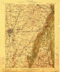
~ Hagerstown MD topo map, 1:62500 scale, 15 X 15 Minute, Historical, 1912
Hagerstown, Maryland, USGS topographic map dated 1912.
Includes geographic coordinates (latitude and longitude). This topographic map is suitable for hiking, camping, and exploring, or framing it as a wall map.
Printed on-demand using high resolution imagery, on heavy weight and acid free paper, or alternatively on a variety of synthetic materials.
Topos available on paper, Waterproof, Poly, or Tyvek. Usually shipping rolled, unless combined with other folded maps in one order.
- Product Number: USGS-5368214
- Free digital map download (high-resolution, GeoPDF): Hagerstown, Maryland (file size: 11 MB)
- Map Size: please refer to the dimensions of the GeoPDF map above
- Weight (paper map): ca. 55 grams
- Map Type: POD USGS Topographic Map
- Map Series: HTMC
- Map Verison: Historical
- Cell ID: 54978
- Scan ID: 257456
- Woodland Tint: Yes
- Survey Year: 1910
- Datum: Unstated
- Map Projection: Unstated
- Map published by United States Geological Survey
- Map Language: English
- Scanner Resolution: 600 dpi
- Map Cell Name: Hagerstown
- Grid size: 15 X 15 Minute
- Date on map: 1912
- Map Scale: 1:62500
- Geographical region: Maryland, United States
Neighboring Maps:
All neighboring USGS topo maps are available for sale online at a variety of scales.
Spatial coverage:
Topo map Hagerstown, Maryland, covers the geographical area associated the following places:
- Eastland Hills - Long Meadow - Northridge Manor - Lens Rambles - Pleasant Walk - Boonsboro - Pondsville - Northaven Mobile Home Park - Harp - State Line - Fairmount - Beaverbrook - Jefferson Heights - Kline Mill - Mount Pleasant - Fountain Head - Hopkins Ridge - Breathedsville - Rouzerville - Ashley - North Lynch Estates - Brightwood Acres - Crestview - Wolfsville Crossing - Flook Farm - Funkstown - Shockeys (historical) - Waterloo - Wood Point - McIntyre Estates - Reid - Jerusalem - Mount Aetna - Lurose Estates - Hunter Hill - Roxbury - Countryside - Greenvale Village - Forest Hills - Trengail Manor - Waterloo - Terrace Hills - Frederick Manor - Hill Village - Bittle - Meeting House Overlook - Potomac Manor - Holiday Acres - Turkey Hill - Antietam Farmettes - Garfield - Midvale - Edgewood Hill - Wayne Heights - Country Squire Estates - Pen Mar Park - Antietam Manor - Mount Lena - Vardo - Sycamore Heights - Fortney Mobile Home Park - Greensburg - Church Hill Estates - Winding Creek South - Paramount - Vista Farms - Weller Farm - Londontowne - Hamilton Park - Fishers Hollow - Pen Mar - Middlepoint - Lynch Estates - Blank - Alpine View - Cool Hollow Estates - Myersville - Mountain View Estates - Emmertsville - Benevola - Woodland Way - Blue Mountain - Beaver Creek Estates - Fountain Head Heights - Fiddlesburg - Fairplay - Jugtown - Mousetown - Millpoint - Longview Estates - Spring Valley - June Acres - Rocky Forge - Meadow Ridge - Fairgreen Acres - Middle Creek Estates - Tilghmanton - Holiday Farms - Wagners Crossroads - Robinwood
- Map Area ID: AREA39.7539.5-77.75-77.5
- Northwest corner Lat/Long code: USGSNW39.75-77.75
- Northeast corner Lat/Long code: USGSNE39.75-77.5
- Southwest corner Lat/Long code: USGSSW39.5-77.75
- Southeast corner Lat/Long code: USGSSE39.5-77.5
- Northern map edge Latitude: 39.75
- Southern map edge Latitude: 39.5
- Western map edge Longitude: -77.75
- Eastern map edge Longitude: -77.5


