
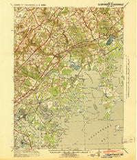
~ Gunpowder MD topo map, 1:62500 scale, 15 X 15 Minute, Historical, 1941
Gunpowder, Maryland, USGS topographic map dated 1941.
Includes geographic coordinates (latitude and longitude). This topographic map is suitable for hiking, camping, and exploring, or framing it as a wall map.
Printed on-demand using high resolution imagery, on heavy weight and acid free paper, or alternatively on a variety of synthetic materials.
Topos available on paper, Waterproof, Poly, or Tyvek. Usually shipping rolled, unless combined with other folded maps in one order.
- Product Number: USGS-5368208
- Free digital map download (high-resolution, GeoPDF): Gunpowder, Maryland (file size: 9 MB)
- Map Size: please refer to the dimensions of the GeoPDF map above
- Weight (paper map): ca. 55 grams
- Map Type: POD USGS Topographic Map
- Map Series: HTMC
- Map Verison: Historical
- Cell ID: 54940
- Scan ID: 257453
- Woodland Tint: Yes
- Aerial Photo Year: 1940
- Datum: NAD27
- Map Projection: Polyconic
- Map published by United States Army Corps of Engineers
- Map published by United States Army
- Map Language: English
- Scanner Resolution: 600 dpi
- Map Cell Name: Gunpowder
- Grid size: 15 X 15 Minute
- Date on map: 1941
- Map Scale: 1:62500
- Geographical region: Maryland, United States
Neighboring Maps:
All neighboring USGS topo maps are available for sale online at a variety of scales.
Spatial coverage:
Topo map Gunpowder, Maryland, covers the geographical area associated the following places:
- Holly Beach - Jerusalem - Hopkins Landing - Woodward Square - Bowleys Quarters - Stansbury Estates - Germantown - Magnolia Estates Mobile Home Park - Whippoorwill Trailer Park - Wesley Woods - Perry Hall Estates - Chesaco Park - Johnson Manor - Bradshaw - Walnut Hills Estates - Edgewater Village - Silver Woods - Stockton - Cunninghill Cove - Richlyn Manor - Joppa Landing - Inverness - Village of Silver Hall - Williams Estates - Claggerts Forest - Baldwin - Harford Furnace - Woodlea - Fork - Village of Pawner - West Twin River - Bagley - Essexshire - Hartley (historical) - Box Hill North - Harford Commons - Kings Country - Jenkins - Crestwood Acres - North Point - Urbanwood - Stoneleigh Square - Sylvania Mobile Home Park - Southfield at Whitemarsh - Exeter Green - Brookhurst - Barrington - Breezy Point Beach - Bradford Barrens - Joppa Vale - Gittings - Charlesmont - Mountain View Estates - Stoneybrook - Jerusalem Mills - Broadview - Woodcrest - Williams Mobile Home Park - Foster Branch - Batter Brook Farms - Silver Manor - Oliver Beach - Clayton - Back River Highlands - Silver Spring Station - Laurel Valley - Twin Brook Estates - Airport Beach (historical) - Holman Manor - Victory Villa - Correlli Estates - Emmorton - Gunpowder - Oaks of Harford - Middle River - Philadelphia Station - Cedarside Farm - Martin Manor - Gray Haven - Joppa Acres - Reckford - Lynchs Corner - Hartland Run - Hartland Village - Gray Manor - Necker - McGuigan Park - Canterbury - Glenmar - Fox Ridge Manor - Harewood - McComas - Ashby Place - Kingsville - Golden Ring - Nottingham Woods - Mount Vista Estates - Lynnhurst - Berkfield - Silver Meadow
- Map Area ID: AREA39.539.25-76.5-76.25
- Northwest corner Lat/Long code: USGSNW39.5-76.5
- Northeast corner Lat/Long code: USGSNE39.5-76.25
- Southwest corner Lat/Long code: USGSSW39.25-76.5
- Southeast corner Lat/Long code: USGSSE39.25-76.25
- Northern map edge Latitude: 39.5
- Southern map edge Latitude: 39.25
- Western map edge Longitude: -76.5
- Eastern map edge Longitude: -76.25


