
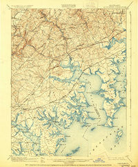
~ Gunpowder MD topo map, 1:62500 scale, 15 X 15 Minute, Historical, 1901, updated 1930
Gunpowder, Maryland, USGS topographic map dated 1901.
Includes geographic coordinates (latitude and longitude). This topographic map is suitable for hiking, camping, and exploring, or framing it as a wall map.
Printed on-demand using high resolution imagery, on heavy weight and acid free paper, or alternatively on a variety of synthetic materials.
Topos available on paper, Waterproof, Poly, or Tyvek. Usually shipping rolled, unless combined with other folded maps in one order.
- Product Number: USGS-5368204
- Free digital map download (high-resolution, GeoPDF): Gunpowder, Maryland (file size: 9 MB)
- Map Size: please refer to the dimensions of the GeoPDF map above
- Weight (paper map): ca. 55 grams
- Map Type: POD USGS Topographic Map
- Map Series: HTMC
- Map Verison: Historical
- Cell ID: 54940
- Scan ID: 257451
- Imprint Year: 1930
- Survey Year: 1900
- Datum: NAD
- Map Projection: Polyconic
- Map published by United States Geological Survey
- Map Language: English
- Scanner Resolution: 600 dpi
- Map Cell Name: Gunpowder
- Grid size: 15 X 15 Minute
- Date on map: 1901
- Map Scale: 1:62500
- Geographical region: Maryland, United States
Neighboring Maps:
All neighboring USGS topo maps are available for sale online at a variety of scales.
Spatial coverage:
Topo map Gunpowder, Maryland, covers the geographical area associated the following places:
- Woodcrest - Clayton Manor - Exeter Green - Crestwood Acres - Bowleys Quarters - Glenmar Manor - Chesaco Park - Hawthorne - Grange - White Oak Crest - Clayton - Annes Delight - Bagleys Venture - Silver Gate Village - Mountvista - Edgewater - Woodlea - Van Bibber - Long Beach Estates - Briarwood Estate - Perry View - Baldwin - Miami Beach - Stansbury Estates - Hunters Run - Temple Hills - Island View Beach - Edgewood Heights - Meadowood - Village of Bynum Run - Mountain View Estates - Long Bar Harbor - Carrollwood Manor - Berryhill - Stemmers Run - Clear Acres - Laurel Valley - Canterbury - Fontana Village - Stoneleigh Square - Gunpowder Estates - Wilson Point - Middlesex - Nottingham Woods - Silver Spring Station - Perry Hall - Perry Hall Park - Johnson Manor - Edgewater Village - Harford Mobile Village - Hartland Village - Cunninghill Cove - Harewood Park - Trimble Fields - Cool Breeze Mobile Home Park - Airport Beach (historical) - Inverness - Willoughby Court - Box Hill South - Bush - Holly Beach - Mount Bush Estates - Bagley - Constant Friendship - Urbanwood - Woodland Run - Pleasant Hills - Forge Acres - Oakhurst - Laurelvale - Regwood - Margate - Bird River Beach - Valleybrook - Cape May Landing - Kingswood - The Pointe - Philadelphia Station - Woodbridge Center - Rockaway Beach - Greenwood - Oaks of Harford - Peppermint Woods Mobile Home Park - Franklinville - Harford Manor - Millwood - Perry's Mobile Home Park - Stoneybrook - Magnolia Estates Mobile Home Park - Cape May Beach - Plumtree Estates - West Twin River - Carrollwood - Claggerts Forest - Reckford - Joppa - Forge Heights - Williams Estates - Osborns Ruins - Victory Villa
- Map Area ID: AREA39.539.25-76.5-76.25
- Northwest corner Lat/Long code: USGSNW39.5-76.5
- Northeast corner Lat/Long code: USGSNE39.5-76.25
- Southwest corner Lat/Long code: USGSSW39.25-76.5
- Southeast corner Lat/Long code: USGSSE39.25-76.25
- Northern map edge Latitude: 39.5
- Southern map edge Latitude: 39.25
- Western map edge Longitude: -76.5
- Eastern map edge Longitude: -76.25


