
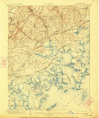
~ Gunpowder MD topo map, 1:62500 scale, 15 X 15 Minute, Historical, 1901, updated 1922
Gunpowder, Maryland, USGS topographic map dated 1901.
Includes geographic coordinates (latitude and longitude). This topographic map is suitable for hiking, camping, and exploring, or framing it as a wall map.
Printed on-demand using high resolution imagery, on heavy weight and acid free paper, or alternatively on a variety of synthetic materials.
Topos available on paper, Waterproof, Poly, or Tyvek. Usually shipping rolled, unless combined with other folded maps in one order.
- Product Number: USGS-5368202
- Free digital map download (high-resolution, GeoPDF): Gunpowder, Maryland (file size: 9 MB)
- Map Size: please refer to the dimensions of the GeoPDF map above
- Weight (paper map): ca. 55 grams
- Map Type: POD USGS Topographic Map
- Map Series: HTMC
- Map Verison: Historical
- Cell ID: 54940
- Scan ID: 257449
- Imprint Year: 1922
- Survey Year: 1900
- Datum: Unstated
- Map Projection: Unstated
- Map published by United States Geological Survey
- Map Language: English
- Scanner Resolution: 600 dpi
- Map Cell Name: Gunpowder
- Grid size: 15 X 15 Minute
- Date on map: 1901
- Map Scale: 1:62500
- Geographical region: Maryland, United States
Neighboring Maps:
All neighboring USGS topo maps are available for sale online at a variety of scales.
Spatial coverage:
Topo map Gunpowder, Maryland, covers the geographical area associated the following places:
- Shady Oaks - Hartley (historical) - Eagle Nest - Middlesex - White Oak Crest - Essexshire Gate - Oakdale - Singer - Greenwood - Clayton - Silver Meadow - Back River - Perry Hall Estates - Claggerts Forest - White Marsh Station - Joppatowne - Fontana Village - McGuigan Park - Hines Estates - North Point - Clearview - Constant Friendship - Ivy Hill - Riverwood Park - Jerusalem - Essex - Greenwood Manor - Scholar Woods - Woodsdale - Harford Furnace - Woodale Homes - Edgewater - Wesley Woods - Glenbauer - Batter Brook Farms - Mountain View Estates - Briarwood Estate - Bonaparte Estates - Silver Gate Village - Woodlea - Bagleys Venture - Berryhill - Carroll Island - Dundee Village - Oaklyn Manor - Bush - Village of Pawner - Gunpowder Estates - Battle Grove - Cedarside Farm - Williams Mobile Home Park - Regwood - Long Beach Estates - Beechwood Mobile Home Park - Baldwin Estates - Bradford Barrens - Urbanwood - Bynum Overlook - Carrollwood - Village of Silver Hall - Kingswood - Darleigh Manor - Fork - Green Springs Hills - Stockton Green - Kingsville - Pleasant Hills - Perryvale - Berkfield - Van Bibber - Miami Beach - Arbour Green - Len Mar Community - Annes Delight - Aero Acres - Village of Bynum Run - Glenmar - Dunwood - Valley View - Whitemarsh Estates - Back River Highlands - Bagley - Harbour Oaks - Victory Villa - Wilna - Willoughby Court - Fox Ridge Manor - The Cedars - Kings Court - Ballard Gardens - Joppa Acres - Harford Commons - Open Acres Manor - Lincrest - Bird River Beach - Temple Hills - Woodland Run - Bowleys Quarters - Woodward Square - Harford Square
- Map Area ID: AREA39.539.25-76.5-76.25
- Northwest corner Lat/Long code: USGSNW39.5-76.5
- Northeast corner Lat/Long code: USGSNE39.5-76.25
- Southwest corner Lat/Long code: USGSSW39.25-76.5
- Southeast corner Lat/Long code: USGSSE39.25-76.25
- Northern map edge Latitude: 39.5
- Southern map edge Latitude: 39.25
- Western map edge Longitude: -76.5
- Eastern map edge Longitude: -76.25


