
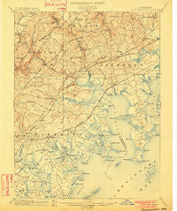
~ Gunpowder MD topo map, 1:62500 scale, 15 X 15 Minute, Historical, 1901
Gunpowder, Maryland, USGS topographic map dated 1901.
Includes geographic coordinates (latitude and longitude). This topographic map is suitable for hiking, camping, and exploring, or framing it as a wall map.
Printed on-demand using high resolution imagery, on heavy weight and acid free paper, or alternatively on a variety of synthetic materials.
Topos available on paper, Waterproof, Poly, or Tyvek. Usually shipping rolled, unless combined with other folded maps in one order.
- Product Number: USGS-5368196
- Free digital map download (high-resolution, GeoPDF): Gunpowder, Maryland (file size: 9 MB)
- Map Size: please refer to the dimensions of the GeoPDF map above
- Weight (paper map): ca. 55 grams
- Map Type: POD USGS Topographic Map
- Map Series: HTMC
- Map Verison: Historical
- Cell ID: 54940
- Scan ID: 257446
- Survey Year: 1900
- Datum: Unstated
- Map Projection: Unstated
- Map published by United States Geological Survey
- Map Language: English
- Scanner Resolution: 600 dpi
- Map Cell Name: Gunpowder
- Grid size: 15 X 15 Minute
- Date on map: 1901
- Map Scale: 1:62500
- Geographical region: Maryland, United States
Neighboring Maps:
All neighboring USGS topo maps are available for sale online at a variety of scales.
Spatial coverage:
Topo map Gunpowder, Maryland, covers the geographical area associated the following places:
- Emmorton - Goldentree - Country Walk - Pleasant Hills - Lynchs Corner - Port Cherry Gardens Farm - Island View Beach - Lawrence Hill - The Pointe - Edgewater Village - Gunpowder - Tremper Farm - Fontana Village - Lincrest - Woodbridge Center - Turkey Point - Forge Heights - Cunninghill Cove - Laurel Woods - Hyde Park - Van Bibber - Walnut Hills Estates - Rockaway Beach - The Cedars - Willoughby Woods - Perry's Mobile Home Park - Northwind Farms - Millwood - Glenwood Trailer Park - Essexshire Gate - Marine Oak Village - Whitemarsh Estates - Fullerton Farms - Nottingham Woods - Woodsdale - Broadview - Perry Hall Village - West Twin River - Perry Hall - Woodlyn Meadows - Eagle Nest - Clayton - Ballard Gardens - Cedarside Farm - Victory Villa - Temple Hills - Claggerts Forest - Annes Delight - Joppa Landing - Trimble Fields - Len Mar Community - Regwood - Gunpowder Estates - Batter Brook Farms - Charlesmont - Village of Bynum Run - Carroll Island - Woodward Square - North Point Village - Willoughby Court - Scholar Woods - Airport Beach (historical) - Magnolia Estates Mobile Home Park - Bonaparte Estates - Hallfield Manor - Carrollwood - White Marsh - Stoneybrook - Sylvania Mobile Home Park - Richlyn Manor - Beechwood Mobile Home Park - Woodsdale Meadows - Battle Grove - Breezy Point Beach - Inverness - Laurelvale - Joppa - Bird River Beach - Kingsville - Sleepy Hollow Mobile Home Park - Hartley (historical) - Country Ridge - Oaklyn Manor - Jerusalem Mills - Long Green Woods - McComas - Kingswood - Glenmar Manor - Clear Acres - Hawthorne - Lereley - Reeds at Bayview Mobile Home Park - Perry Hall Estates - Harford Furnace - Shannon Heath - Exeter Green - Edgewood Heights - Joppatowne - Glenmar - Valley View
- Map Area ID: AREA39.539.25-76.5-76.25
- Northwest corner Lat/Long code: USGSNW39.5-76.5
- Northeast corner Lat/Long code: USGSNE39.5-76.25
- Southwest corner Lat/Long code: USGSSW39.25-76.5
- Southeast corner Lat/Long code: USGSSE39.25-76.25
- Northern map edge Latitude: 39.5
- Southern map edge Latitude: 39.25
- Western map edge Longitude: -76.5
- Eastern map edge Longitude: -76.25


