
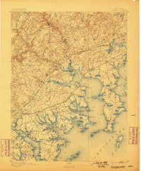
~ Gunpowder MD topo map, 1:62500 scale, 15 X 15 Minute, Historical, 1893, updated 1898
Gunpowder, Maryland, USGS topographic map dated 1893.
Includes geographic coordinates (latitude and longitude). This topographic map is suitable for hiking, camping, and exploring, or framing it as a wall map.
Printed on-demand using high resolution imagery, on heavy weight and acid free paper, or alternatively on a variety of synthetic materials.
Topos available on paper, Waterproof, Poly, or Tyvek. Usually shipping rolled, unless combined with other folded maps in one order.
- Product Number: USGS-5368194
- Free digital map download (high-resolution, GeoPDF): Gunpowder, Maryland (file size: 10 MB)
- Map Size: please refer to the dimensions of the GeoPDF map above
- Weight (paper map): ca. 55 grams
- Map Type: POD USGS Topographic Map
- Map Series: HTMC
- Map Verison: Historical
- Cell ID: 54940
- Scan ID: 257445
- Imprint Year: 1898
- Survey Year: 1891
- Datum: Unstated
- Map Projection: Unstated
- Map published by United States Geological Survey
- Map Language: English
- Scanner Resolution: 600 dpi
- Map Cell Name: Gunpowder
- Grid size: 15 X 15 Minute
- Date on map: 1893
- Map Scale: 1:62500
- Geographical region: Maryland, United States
Neighboring Maps:
All neighboring USGS topo maps are available for sale online at a variety of scales.
Spatial coverage:
Topo map Gunpowder, Maryland, covers the geographical area associated the following places:
- Plumtree Estates - Middlesex - Baldwin - Harford Landing - Joppa View - Southfield at Whitemarsh - Philadelphia Station - Stoneybrook - Arbour Green - Chase - Lawrence Hill - Inverness - Village of Church Creek - Scholar Woods - Stoneleigh Square - Laurel Woods - White Marsh Station - Twin Brook Estates - Glenmar - Bush - Joppa - Reeds at Bayview Mobile Home Park - Wildwood Beach - Canterbury - Harewood - Stockton Green - Norris Corner - Van Bibber Manor - Lincrest - Mansfield Woods - Berryhill - Woodsdale - Edgewater Village - Perry Hall Village - Clayton - Harmony Hills - Silver Gate Village - Crestwood Acres - Victory Villa Gardens - Walnut Hills Estates - Brierwood - Hopkins Landing - Woodbridge Center - Mount Bush Estates - Crisfield Crossing - Harford Manor - Courts of Harford Square - Hartland Village - Bynum Hills - Upper Falls - Oaks of Harford - Ballard Gardens - Oakhurst - West Shore - Gunpowder Estates - Whitemarsh Estates - Berkfield - Williams Mobile Home Park - Country Walk - North Point Village - Charlesmont - Marine Oak Village - Clearview - Woodale Homes - Ivy Hill - Peppermint Woods Mobile Home Park - White Oak Crest - Glenbauer - Harewood Park - Fullerton Farms - Marys Choice - Pembrook - Silver Woods - Hartland Run - Johnson Manor - Carrollwood - Essexshire Gate - Turkey Point - Fox Ridge Manor - Greenwood - Tarton Hill - Box Hill North - Hydes - Golden Ring - Stemmers Run - Bagley - Abingdon - Perry Hall Park - Miami Beach - Cool Breeze Mobile Home Park - Hines Estates - Hyde Park - Perry Hall - Broadview - Dunwood - Harford Commons - Bradshaw - Glenmar Manor - Gray Manor - Bagleys Venture
- Map Area ID: AREA39.539.25-76.5-76.25
- Northwest corner Lat/Long code: USGSNW39.5-76.5
- Northeast corner Lat/Long code: USGSNE39.5-76.25
- Southwest corner Lat/Long code: USGSSW39.25-76.5
- Southeast corner Lat/Long code: USGSSE39.25-76.25
- Northern map edge Latitude: 39.5
- Southern map edge Latitude: 39.25
- Western map edge Longitude: -76.5
- Eastern map edge Longitude: -76.25


