
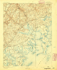
~ Gunpowder MD topo map, 1:62500 scale, 15 X 15 Minute, Historical, 1893
Gunpowder, Maryland, USGS topographic map dated 1893.
Includes geographic coordinates (latitude and longitude). This topographic map is suitable for hiking, camping, and exploring, or framing it as a wall map.
Printed on-demand using high resolution imagery, on heavy weight and acid free paper, or alternatively on a variety of synthetic materials.
Topos available on paper, Waterproof, Poly, or Tyvek. Usually shipping rolled, unless combined with other folded maps in one order.
- Product Number: USGS-5368192
- Free digital map download (high-resolution, GeoPDF): Gunpowder, Maryland (file size: 8 MB)
- Map Size: please refer to the dimensions of the GeoPDF map above
- Weight (paper map): ca. 55 grams
- Map Type: POD USGS Topographic Map
- Map Series: HTMC
- Map Verison: Historical
- Cell ID: 54940
- Scan ID: 257444
- Survey Year: 1891
- Datum: Unstated
- Map Projection: Unstated
- Map published by United States Geological Survey
- Map Language: English
- Scanner Resolution: 600 dpi
- Map Cell Name: Gunpowder
- Grid size: 15 X 15 Minute
- Date on map: 1893
- Map Scale: 1:62500
- Geographical region: Maryland, United States
Neighboring Maps:
All neighboring USGS topo maps are available for sale online at a variety of scales.
Spatial coverage:
Topo map Gunpowder, Maryland, covers the geographical area associated the following places:
- Jerusalem - Lynnhurst - Tarton Hill - Ken Lee Mobile Home Courts - Hartley (historical) - Hines Estates - Harewood - Harmony Hills - Hallfield Manor - Mars Estates - Jerusalem Mills - Dunwood - Cool Breeze Mobile Home Park - Perry Hall Park - Ballard Gardens - Batter Brook Farms - Van Bibber - Ivy Hill - Van Bibber Manor - Holly Beach - Mountain View Estates - Beechwood Mobile Home Park - Singer Woods - Lynchs Corner - Briarwood Estate - Village of Bynum Run - Seneca Park - Berkfield - Marine Oak Village - Wildwood Beach - Abingdon Reserve - Joppa Landing - Cochran Hills - Island View Beach - North Point Village - Franklinville - Biscayne Bay Village - Woodlyn Meadows - Clearview - Reeds at Bayview Mobile Home Park - Upper Falls - Joppa Vale - Harford Commons - Constant Branch - Gittings - Dundee Village - Beachwood - Whippoorwill Trailer Park - Tremper Farm - Long Green Woods - Baldwin - Pinedale - Forge Heights - Village of Church Creek - Williams Estates - Long Bar Harbor - Annes Delight - Sue Creek Landing - Essexshire - Woodcrest - Bonaparte Estates - Bagley - Fullerton Farms - Eagle Nest - Shady Oaks - Correlli Estates - Mount Vista Estates - Victory Villa - Marys Choice - Plumtree Estates - Abingdon - White Marsh - Turkey Point - Crestwood Acres - The Cedars - Bynum Overlook - Harbour Oaks - Pembrook - Chesaco Park - Northwind Farms - Overview Manor - Regwood - Chapel Manor - Hartland Run - Country Walk - Mansfield Woods - Harford Square - North Point - Perry View - Josenhans - Harford Furnace - Hydes - Kings Court - Hawthorne - Scholar Woods - Harford Manor - Middlesex - Wampler Village - Edgewater Village - Cedarside Farm
- Map Area ID: AREA39.539.25-76.5-76.25
- Northwest corner Lat/Long code: USGSNW39.5-76.5
- Northeast corner Lat/Long code: USGSNE39.5-76.25
- Southwest corner Lat/Long code: USGSSW39.25-76.5
- Southeast corner Lat/Long code: USGSSE39.25-76.25
- Northern map edge Latitude: 39.5
- Southern map edge Latitude: 39.25
- Western map edge Longitude: -76.5
- Eastern map edge Longitude: -76.25


